![]()
CHAPTER 4 - LULC DYNAMICS: THE COLONIZATION IMPACT
4.4. The colonization impact in Machadinho and Anari
In the beginning of this chapter, I called attention to the importance of geotechnologies in supporting the study of LULC dynamics in Amazônia. Through a brief literature review, the need of spatial-temporal assessments related to the subject was emphasized and the research was included in this methodological context. After going through the results achieved at distinct units of analysis (i.e., settlement, buffers around roads, reserves, and rural properties), this section discusses the impact of this research for a better understanding about trajectories of LULC in the study area and in Amazonian frontiers of colonization. For this purpose, the section is divided in three main aspects: the methodological and operational issues; the main findings and their meanings; and the trajectories of LULC and trends for the near future.
4.4.1. Methodological and operational issues
LULC classification in Amazônia is a complex task and its degree of difficulty increases with the number of classes one wants to distinguish. Spectral signatures detected by TM images often include mixed responses for the heterogeneous tropical environment. More than just distinct vegetation types, LULC cover classes represent scenarios within the complex dynamics of vegetation clearing or recovering. In addition, the process occurs at remote and large areas, sometimes of difficult access. Lack of data, such as soil and topographic maps at detailed scale, also complicates the process of classification. In sections 3.5 and 4.1, aspects related to the use of spectral analysis and vegetation structure for understanding LULC dynamics in the Amazon are mentioned. This section discusses some operational and methodological issues faced when tracking the colonization impact in the study area using remote sensing tools.
Some problems are merely operational (e.g., the lack of image data for the southern portion of Anari in 1988 and 1994 or detailed soil maps). Other questions are methodological, such as to use a reasonable classification system to describe the variance of LULC dynamics at the scale and complexity of study. One way to surpass such difficulty is to increase the fieldwork effort by gathering more ground-truth data. In the case of Machadinho and Anari, the total area to be covered (3,383 km2) was reasonably large to include multiple scenarios within the distinct landscapes and LULC outcomes. During fieldwork, overview flights were carried out in small planes. I also drove through all dirt roads, and walked through properties and forest reserves. The challenge was not just to acquire training data to inform image classifications. It was also to understand the responses of local people to processes of LULC change and landscape transformation. For this reason, interviews with local people were carried out, helping to achieve a better conceptual approach about local heterogeneity in LULC.
Accuracy assessment of LULC classifications brought attention to some aspects. In areas of steeper topography, mainly along orthogonal roads of Anari crossing ridges and valleys, ground truthing indicated that some agricultural fields and bareland should have been classified as pasture. The confusion between bareland and pasture becomes worse with overgrazing during the dry season, when soil spectral response contributes more significantly to the signature of sparsely covered grassy vegetation. On the other hand, degraded pasture in the process of vegetation recovery often has high densities of Vismia sp. and Orbignya sp., generating confusion with the spectral response for SS1 or even perennial agriculture. Spectral responses for perennial agriculture can also be confused with SS1, mainly in areas of initial recovery of disturbed gallery vegetation. One way of reducing the risk of misclassification would to group classes such as pasture, agriculture, and bareland as a class named 'production,' or collapsing the stages of secondary succession into just one class, which was done for the computation of transition matrices and for the calculation of landscape metrics described in the next chapter. This produces more accurate classifications but at a cost of generalizing LULC classes drastically, not allowing the generation of results such as the ones presented in this chapter.
To overcome possible problems related to the chosen classification system, extensive fieldwork during the dry seasons of 1999 and 2000 and previous studies supported the description of LULC categories and production systems in the area (Miranda and Mattos 1993; Miranda et al. 1997, 1997a). The proximity of Machadinho and Anari also made the study possible by easing the access to most portions of the area under investigation. Also, possible methodological problems related to image classification can be assumed to be similar in both settlements.
4.4.2. Main findings and their meanings
The results presented in this chapter were produced at distinct units of analysis. This method allowed addressing LULC dynamics in a multi-scale manner, from the landscape (settlement) to the property. The landscape-based analysis provided a general picture about the process in Machadinho and Anari. As expected and assumed at the beginning of this research, both settlements had similar LULC in 1988. This holds for all classes mapped, except for agriculture and bareland. Despite the fact these classes had small land cover at the time, the percentage of agricultural lands in Anari is three times greater than in Machadinho, and the percentage of bareland is twice greater in the former settlement (Table 14). As explained in Chapter 2, Anari settlement was started about two years before Machadinho. These numbers indicate that the process of farm occupation was a little more advanced in Anari in 1988. In 1998, after experiencing many production systems and coping with distinct policies, incentives, and local biophysical heterogeneity, farmers produced a different outcome, with Anari showing a clear trajectory toward higher rates of deforestation and pasture conversion.
As far as intra-settlement spatial patterns are concerned, some findings deserve attention and were corroborated during fieldwork. In Machadinho, larger patches of pasture occur mainly along two roads: MC-7 and MC-6, at the northern and eastern portions of the settlement, respectively. According to local landowners and extensionists, these are zones within the settlements where the less fertile soils occur. Although there are no detailed soil maps available for the area, it makes sense to expect that the rate of abandonment by original landowners and land aggregation for pasture conversion by speculators will be higher in less fertile areas. Within the center of the settlement, properties remain with their original sizes and are mainly cultivated with coffee plantations or mixed production systems including agriculture and pasture.
In Anari, other important patterns were found. Large patches of pasture occur along the main road and at the ends of secondary roads. Here, besides soil fertility, access is also affecting the process of pasture conversion and land aggregation. Along the main road, first colonists and opportunists took over the land with better access and converted it rapidly to pasture to ensure their tenure status. In marginal areas at the border of the settlement, speculators took over abandoned lots, as they did in Machadinho. In these areas, access is poor through dirt roads trafficable only during the dry season, making cattle the only choice of production. Interesting enough, the sector of Anari called 'line of agriculture' by the local population is located at the northern portion of the settlement in mild topography. Besides better access to the urban area and proximity with Machadinho, better soils occur in this area, according to landowners and extensionists.
Section 4.3.2 presented the results for the study of agroecological processes using transition matrices between the multi-temporal classifications. Deforestation processes are clearly associated with roads, urban areas did not grow significantly, production patches follow the deforestation patches, and secondary succession patches often occur further from roads.
The results for production and succession (Figures 58 and 59) do not allow conclusions about intensification or extensification of production systems in Machadinho and Anari. All that can be said is that area in production (pasture and agriculture) is greater in Anari. However, a careful analysis of the results at the settlement- and the property-level indicates a trend. At the settlement level, Table 14 shows that Anari has more pasture in 1998, both in area and percentage. The numbers for agriculture show a different picture. Although the percentage of the settlement covered by this land use is greater in Anari, the rate of agriculture conversion in Machadinho is higher. These opposite trends are clearly shown by the areas of pasture and agriculture per property (Tables 17 - 22). In Machadinho, the area of agriculture increases from 0.5 ha in 1988 to 4.4 ha per property in 1998, while the area of pasture goes from 2.8 ha to 5.9 ha during the same period. In Anari, the numbers for agriculture are 1.4 ha in 1988 and 5.2 ha in 1998 (higher, but not very different from Machadinho), while pasture area grew rapidly from 2.8 ha to 8.1 ha per property during the same period. This analysis at the property level avoids misinterpretations of results obtained for the entire settlement, as Machadinho has more properties than Anari and properties in Anari are on average larger than in Machadinho.
Still through the transition matrices, it was possible to depict spatial patterns for recent clearings in both settlements. Large areas being cleared are often associated with pasture conversion and are adjacent to other pasture areas. Smaller areas being cleared are located further from roads and are generally associated with the expansion of agricultural fields. Interviews with Anari landowners during fieldwork shed some light on this pattern. According to them, agricultural fields develop better in areas closer to forests because of a cooler microclimate. Moreover, they try to keep these fields at a certain distance from pastures, as the latter are frequently managed through the use of fire. In Machadinho, this pattern is not so clear, as the curvilinear road design does not follow an orthogonal distribution of production fields as in Anari. In addition, this finding is valid only for properties with mixed production systems including agriculture and cattle ranching.
Section 4.3.3 showed the relative importance of communal forest reserves in maintaining a higher percentage of forest cover in Machadinho. The institutional aspects regarding rules in use and interactions among different actors within the settlement are discussed in Chapter 6. The important point here is to reaffirm that the percentage of forest cover in Machadinho in 1998 would be the same as in Anari if the reserves did not exist (i.e., 51%). This brings up an important discussion about the limits of deforestation in Amazônia and in Rondônia, also valid for the results at the property level. Arguments about a reasonable 'Forestry Code' ruling the region are currently in debate. The Brazilian Congress seeks to determine a percentage of deforestation allowed by law. This percentage was of 50%, but recent discussions have vacillated between reducing and increasing this number.
Moreover, land zoning laws often conflict with the 'Forestry Code', making the subject a complicated issue affected by political and economic interests. The contribution of this research to the topic is that multi-temporal analysis using remote sensing has proved to be an effective tool when comparing the trajectories of settlements in Rondônia. In addition, comparative analysis, such as the one carried out during this research, makes it possible to draw a better picture of the heterogeneity of LULC dynamics in the Amazon, particularly in areas of rural settlements with distinct architectural and institutional designs.
Another aspect analyzed in this chapter is the impact of road system design in LULC change patterns. The results show that deforestation extends further from roads in Anari, which is also reaffirmed by higher rates of recent clearing at the 800-meter buffers around roads within this settlement. Deforested areas tend to percolate first in Machadinho because secondary roads are closer to each other than in Anari. The communal reserves play an important role in maintaining large patches of forest encompassed by the road system. However, the discussion about the importance of road system design to the magnitude of deforestation still requires more research. On one hand, questions related to access may affect the process significantly. In general, marginal areas of difficult access at the end of secondary roads tend to be converted to pasture. This happens for two main reasons. First, as mentioned above, speculators take over these abandoned or underused areas and assure tenure by planting grass and introducing cattle. Second, agriculture is often unviable in these areas because secondary roads are too bad for transportation of produced goods. This process is more visible in Anari, where the orthogonal road design and poor maintenance of roads leads to higher rates of pasture conversion. On the other hand, besides infrastructure, incentives toward specific land uses may affect the decision-making process at the property level, generating a spatial pattern at the settlement level. Farmers in Machadinho had several incentive programs for agricultural production, including coffee, cacao, and agroforestry. Despite their questionable success in terms of economic return for the farmers, the LULC outcome was a more heterogeneous mosaic of production systems at variable distances from roads. Institutional aspects related to farmers' decision making and their possible impacts in LULC dynamics and landscape transformation will be discussed in Chapter 6.
The final unit of analysis was at the property level. Results in both percentage of lot and area, and rates of land conversion to different LULC features, provided a better understanding of the colonization process in Machadinho and Anari. Property results showed a higher percentage and area of deforestation per year in Anari after 1988 (Table 23). Higher rate of deforestation in Machadinho's properties before 1988 is probably due to the fact that this settlement was implemented with infrastructure and incentives for production already in place. In Anari, the implementation phase was more chaotic, as discussed further in Chapter 6. Landowners had to cope with difficulties in access to their lots and to incentives. Once they had adapted to these problems, they started clearing the land rapidly (after 1988), at a rate of deforestation higher than Machadinho. A higher pasture conversion rate was also confirmed for Anari. The variance in terms of area tends to increase with time in all classes in both settlements, indicating different farming strategies implemented by landowners.
Perhaps, property-based analyses for transition matrices and the study of a time series with more intervals could provide a better picture of specific trajectories within the lots. The integration of these results with household data for socioeconomic and agroecological variables may also be a valuable approach to take. However, cloud-free images for other dates and household data for Anari were not available. So, the results were based on the multi-temporal data available and the use of geotechnologies to bring light to general LULC dynamics in Machadinho and Anari. Together with the feedback from local people, some trajectories and trends of LULC may be drawn.
4.4.3. Trajectories of LULC and trends for the near future
The human occupation defined different outcomes in terms of LULC in Machadinho and Anari during the period of study. In 1998, after about 15 years of colonization, properties in both settlements reached an average of approximately 54% of deforestation. The pathways of LULC change underlying the colonization impact is illustrated in Figure 70. Infrastructure and water are not in the graph because they are poorly represented in terms of area in both settlements and their surface did not show significant changes through time (Table 14). However, it is important to mention that the trajectory toward infrastructure and water is diverse. Their patches can be originated from the conversion of any LULC class. Infrastructure includes roads and urban areas. The latter have grown slowly during the period of study through the conversion of forest, SS2, SS1, pasture, agriculture, and bareland. The roads were primarily built during settlement implementation through forest clearing. Newer road building, although rare, may have been converted from any LULC class. The return of infrastructure to other classes is also spatially unimportant but may occur. Water includes rivers and lakes. The former may change their path over time but the effect in terms of area of LULC change is also very small. The lakes, which include water ponds, are generally built for cattle ranching. Their number has increased but their extent is also small.
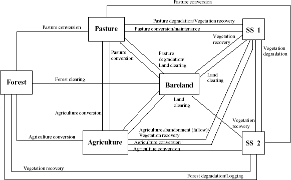
Figure 70 - Trajectories of Land Use/Land Cover in Machadinho d’Oeste and Vale do Anari until 1998.
A more dynamic process occurs between forest, SS2, SS1, pasture, agriculture, and bareland. The trajectories between these classes are associated with cycles of vegetation clearing, degradation, or recovery through the portfolio of strategies among colonists. Forest can be cleared to bareland, converted to pasture or agriculture, and degraded to SS2. Pasture can be cleared or degraded to bareland, converted to agriculture or recovered by SS1. Agriculture can be cleared to bareland, converted to pasture, and recovered after abandonment by SS1. Bareland can be converted to agriculture or pasture, and recovered by SS1. SS1 can be cleared to bareland, converted to pasture or agriculture, or develop to SS2. And SS2 can be cleared to bareland, converted to pasture or agriculture, degrade to SS1, or develop to forest.
A range of factors influences these trajectories and was confirmed during interviews. Local biophysical features can drive LULC changes, mainly because of soil fertility and topography. Distance from roads and urban areas may also affect LULC changes, as mentioned throughout this chapter when explaining higher rates of pasture conversion in Anari. Socioeconomic variables can also impact the outcomes in LULC. Access to credit and incentives, household labor force, previous farming experiences, and available assets are among the most important drivers for land management or abandonment.
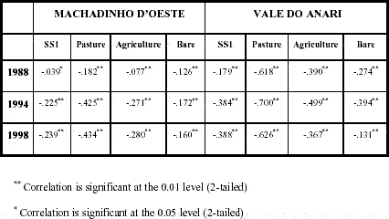
Another important consideration to point out is the meaning of each LULC during the time frame being studied. This not only explains specific trajectories toward LULC change, but also defines trends for the near future. In 1988, for instance, agriculture meant annual crops and young perennial plantations (i.e., coffee, rubber, cacao). SS1 was the only class of vegetation recovery at this early stage of colonization, resulting from abandonment of lots or fields. SS2 did not exist because not enough time had passed for vegetation recovery to occur. Forest, pasture, bareland, infrastructure, and water had the same characteristics as in 1994 and 1998. However, in these two latter years, agriculture was mainly represented by older coffee plantations, secondary succession included different stages of recovery, and more dynamic trajectories were taking place as the internal variance in area of each LULC increased within properties (Tables 17 - 22 and Figures 64 - 69). Pearson correlation also indicates the relationships between changes in forest cover and selected LULC classes. In Anari, loss of forest cover is strongly associated with the pasture extent. Values of -0.618, -0.700, and -0.626 (p<0.01) were found for 1988, 1994, and 1998, respectively. Correlations for SS1, agriculture, and bareland are also higher in Anari, where the deforested area for production at farm lots is greater than in Machadinho (Table 24).
Table 24 - Pearson correlation between forest cover and selected LULC classes in farm lots of Machadinho d’Oeste and Vale do Anari.
Despite major LULC trajectories presented in this chapter, some other trends deserve attention, particularly in agricultural production. In general, trends are represented by experiences with different crops. These crops have attractive economic returns, but also some uncertainty related to market demands. Black pepper is one example. Many farmers have tried to produce it, but they claim it is a difficult and expensive crop to implement. Guaraná (Paulinnia cupana) is relatively difficult to cultivate with high productivity. Palm heart production and mamona seeds for oil production are not reliable crops because market demand and access are questionable for farmers in Machadinho and Anari. Tree plantations for lumber depend on a very long cycle. On the other hand, cacao and rubber tree producers are not happy with the results.
For these reasons, coffee is still the most common option when farmers choose a type of agriculture. Productivity and quality of coffee plantations are often low, but they provide extra income for landowners, who came mostly from southern and southeastern Brazil, and are used to coffee production systems. Last but not least, trends of LULC change for the near future may also be affected by rural and urban development. Rural power lines, mechanization, irrigation, better rural extension practices, and the use of better crop varieties are already being discussed and implemented.
All LULC processes described in this chapter affect landscape transformation in Machadinho and Anari. But the analysis of LULC change by itself does not allow a comprehensive approach about the effect of these processes in the spatial pattern of landscapes, classes, and patches within the settlements. Chapter 5 addresses this matter.