![]()
CHAPTER 2 - ENVIRONMENTAL AND CULTURAL SETTING: THE OPPORTUNITY FOR A COMPARATIVE STUDY
'Aqui vêm os iludido e vão os arrependido'
2.1. Amazônia: a land in search of its destiny
The Amazon River and its affluents form the greatest river system on Earth. The Amazon Basin is bordered by the Andes and the massifs of the Guianas and Central Brazil (Orinoco and Paraná Basins), draining 7 million km2 of land (Sioli 1984). The Brazilian portion of this immense territory is about 5 million km2 and encompasses several ecological systems (Goulding et al. 1996)(Figure 1).
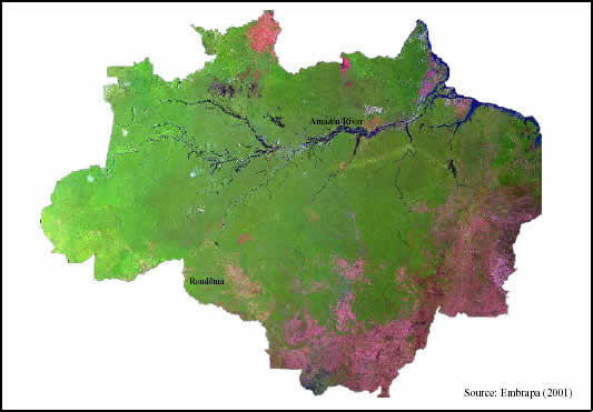
Figure 1 - The Amazon Region seen through a mosaic of Landsat TM images from year 2000 (Bands 3, 4, and 5).
The early discovery and occupation of the Amazon was facilitated by the existence of numerous waterways and a dense river system, which later scientists and explorers also followed. In the mid-1900s a comprehensive picture of the Amazonian ecosystem began to be formed (Sioli 1984). Up to this period, the heterogeneity of the region was obscured by the notion of a vast and homogeneous 'jungle.'
Early studies on the region tried to explain the apparent lack of social complexity by the existence of 'limiting factors,' which would be responsible for relatively low population densities (Behrens 1992). At the risk of being overly simplistic, the rationales behind these debates are briefly mentioned, as extensive literature has already been published about this subject. The classical paper by Meggers (1954) suggested that levels of social complexity are limited by the agricultural potential of soils in the Amazon. Others have argued that protein sources, not necessarily the production of highly caloric crops, has limited population densities throughout the region (Lathrap 1970, Gross 1975, Ross 1978, among others).
Later studies have challenged these views. Archeological evidence has shown the existence of complex prehistoric cultures in the Amazon (Myers 1973, 1989, Roosevelt 1987, 1989a, 1989b). Agronomic and biophysical surveys have found a diversity of soils and land resources, including areas suitable for large-scale agriculture (Falesi 1974, Cochrane and Sánchez 1982, Nicholaides et al. 1984). Beckerman (1979) and Chagnon and Hames (1979) have shown that, in many Amazonian groups, the amount of protein consumed per capita often equals or exceeds amounts consumed in modern Western societies. And, more recently, the process of colonization itself has made it clear that a much more complex picture has to be drawn if we want to understand the potential of the Amazon for development (Moran 1981, 1983, Becker 1982, Schmink and Wood 1984, Bunker 1985, Hecht and Cockburn 1990, Stewart 1994, Almeida 1996).
In general, the trajectory made possible by limiting factors commented above depends on the ability of human cultures to adapt to heterogeneous environmental conditions and to manage these conditions in order to achieve at least the needs of subsistence (Gross et al. 1979, Moran 1982). But the subsistence assumption has also been challenged by the intensification of production systems, as cultural aspects inter-relate dynamically with population growth and market demands (Boserup 1965, Netting 1977). Together with the theoretical debates about the potentials and limitations of the Amazon, several regional and local processes were taking place due to governmental, private, or spontaneous initiatives of colonization.
The processes of colonization in the Amazon have attracted a great deal of attention in recent years, mainly because of the deforestation associated with land appropriation. Large-scale deforestation began in the early 1960s with the relocation of the national capital to Brasília and the construction of a network of roads connecting the region with the south and the northeast portions of the country: Belém-Brasília Highway, Transamazon Highway, Cuiabá-Porto Velho Highway (BR-364), Cuiabá-Santarém Highway, and the Perimetral Norte, among other ancillary roads (Moran, 1993b). Calha Norte and Avança Brasil represent the more recent versions of road development projects for the region. During and after the Program of National Integration (PIN), road building was generally attached to development and colonization projects, international funding by the Inter-American Development Bank and the World Bank, credit lines provided by the Amazonian Bank (BASA) and the Amazonian Development Agency (SUDAM), and establishment of rural settlements by the Brazilian Agency for Colonization and Agrarian Reform (INCRA) (Kohlhepp 1984, Moran 1984, Schmink and Wood 1992, Comision Amazonica de Desarrolo y Medio Ambiente 1993, Browder and Godfrey 1997). In the words of Sioli (1984), " former human interventions in the Amazonian ecosystem were small sized while the modern development plans and enterprises are quantitatively and qualitatively of enormous dimensions. They concern the terrestrial as well as aquatic reaches of the region and consist, as a first step, in total or selective deforestation."
The Amazonian debate has then shifted from limiting factors to the determinants of deforestation. Human and environmental dimensions of the process are also under investigation. Methodological techniques to address these dynamics at a broad scale are becoming available. Estimations about the rate and extension of deforestation, once based on personal perspectives or partial approaches of extrapolation, are now being done with higher accuracy. Studies on vegetation regrowth are showing alternative trajectories in land-use/land-cover (LULC) change. Besides possible deforestation causes, consequences and responses of the process are also being addressed, as a way to suggest scenarios for the future after the learning of the past. Currently, the effects of Amazonian deforestation on global change processes such as atmospheric carbon accumulation are on top of the list. Through a critical literature review, it is evident that the scientific community is now facing similar problems in estimating carbon releases as it faced in the past with quantification of deforestation (Fearnside and Guimarães 1996, Houghton et al. 1998, Salomão et al. 1998). It is virtually impossible to touch on all the issues related to the Amazonian deforestation from the global to the local perspective through the pages dedicated to this chapter. Therefore, the following discussion was restricted to the dynamics of frontier occupation in the Amazon, an already very complex and multi-tiered subject.
After overcoming methodological problems to estimate the amount and rate of deforestation in Amazônia, remote sensing-based studies have shown that the region has been cleared at approximately 0.5% per year since the early 1980s (Malingreau and Tucker 1988, Skole and Tucker 1993, INPE 1999). Other studies have discussed the social, economic, and ecological processes involved during deforestation dynamics (Conant et al. 1983, Brondizio et al. 1994, 1996, B. Turner et al. 1993, Moran et al. 1994, Gerber 1997).
Slowly, scientific studies in several fields started to recognize a more complex picture (Moran 1993b, 1995). On the one hand, some basic findings were generalized for the entire region as 'unifying principles': a general scarcity of nutrients in the soil (Sombroek 1984); a tightly closed, continuous recycling of nutrients within the biomass of the forest (Herrera et al. 1978, Jordan 1989); extreme diversity of the biota (Prance and Lovejoy 1985); and the regional recycling of a large part of the rainwater, crucial for the maintenance of a climate affected by pluvial processes (Schubart and Salati 1982, Dickinson 1987).
On the other hand, the heterogeneity of such a broad territory was recognized in several fields. Among other regional elements, Amazonian river types were differentiated into whitewater (e.g., Solimões-Amazonas, Madeira), clearwater (e.g., Tapajós, Xingu), and blackwater (e.g., Negro) (Sioli 1984). Sombroek (1984) divided soils into three major categories: well-drained soils of the uplands, imperfectly drained soils in the sedimentary parts of the region, and poorly drained soils in várzeas and igapós. Cochrane and Sanchez (1982) provided a more detailed classification and distribution of the Amazonian soils: oxisols (45.5%), ultisols (29.4%), entisols (14.9%), alfisols (4.1%), inceptisols (3.3%), spodosols (2.2%), mollisols (0.8%), and vertisols (0.1%). Gash et al. (1996) and Fisch et al. (1998) revised the regional climate and possible effects of deforestation. Braga (1979), Pires (1984), and Pires and Prance (1985) have described several vegetation types. A myriad of papers have addressed the human dimension behind the environmental heterogeneity (Meggers 1974, Moran 1974, Hames and Vickers 1983, Moran and Herrera 1984, Balée 1989, Posey and Balée 1989, Sponsel 1992).
As a consequence of the increasing knowledge about the region, different development schemes and production systems were described and discussed (Anderson 1990). Among others, shifting cultivation (Beckerman 1983, Denevan et al. 1984, Dufour 1990), agroforestry (Hecht 1982, Nepstad and Schwartzman 1992, Smith et al. 1996, Brondizio and Siqueira 1997), cattle ranching (Falesi 1974), and agriculture with fertilization inputs (Cochrane and Sanches 1982, Nicholaides et al. 1984) are included.
Today, a more reasonable way of thinking about the occupation of the Amazon shifted from 'deforest or not deforest' to 'where, how, and how much to deforest' (Mahar and Ducrot 1998). Embedded in this dynamic process, several modern techniques of environmental assessment were developed. Integration of remote sensing and geographic information systems (GIS) brought the spatial discussion into a broader view of the Amazonian development (Malingreau and Tucker 1990, Conant 1994, Adams et al. 1995, Foody et al. 1996, Hall et al. 1996, Ahern 1998, Moran 1998, Alves 1999). Also, more detailed LULC classifications informed by field data are emphasizing the function of secondary regrowth in Amazonian landscapes (Li et al. 1994, Moran et al. 1994, Lucas et al. 1998). While the deforestation process occurs, secondary vegetation also exists. Thus, issues such as vegetation restoration and succession dynamics should be part of the investigations about land-cover trajectories in the region (Moran et al. 1996).
All these contributions to the knowledge of such a large and diverse region have provided new elements for a better understanding of the colonization process. If we still cannot have a reasonable hope that the rich biodiversity of Amazônia will be saved for future generations, at least we can look at the past and begin to correct the misuse of certain analyses and generalizations. Through this critical approach it may be possible to address complex issues, such as the study of landscape transformation in the State of Rondônia.