![]()
CHAPTER 4 - LULC DYNAMICS: THE COLONIZATION IMPACT
4.3. Land-Use/Land-Cover (LULC) dynamics
4.3.1. Machadinho and Anari: general spatial trends in LULC
Comparison of LULC classes between the two settlements reveals striking differences in landscape change (Table 14). During the early stage of implementation, both settlements had similar percentages of forest and pasture (about 87% and 6%, respectively). Ten years later, forest cover dropped to 51% in Anari in contrast to 66% in Machadinho. Figure 52 shows the forest cover through time in Machadinho and Anari.
Table 14 - Land Use/Land Cover in Machadinho d’Oeste and Vale do Anari in 1988, 1994, and 1998.
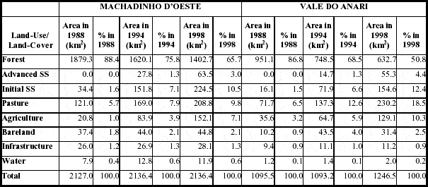
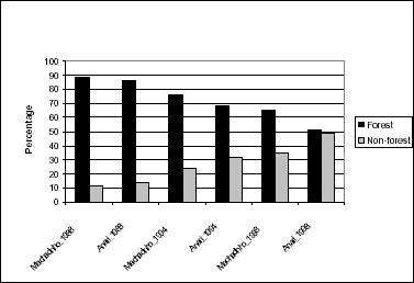
Figure 52 - Percentage of forest and non- forest in Machadinho d’Oeste and Vale do Anari in 1988, 1994, and 1998.
Forest conversion was also different in both areas. In Anari, pastureland increased threefold, while in Machadinho it increased less than twofold (10% of the landscape). While agricultural areas are also larger in Anari (10.3%), Machadinho shows a faster growth of this activity (just 1% in 1988 in comparison to 7% in 1998). According to landowners in both settlements, the condition of agricultural fields is better in Machadinho. This is confirmed by official indices, suggesting a better management of cropland by landowners at this settlement. For example, the productivity of corn in Machadinho is 1,200 kg/ha while in Anari it is just 1,000 kg/ha (IBGE 2000b).
An indication of a slightly higher percentage of abandonment of agricultural fields as well as pasture areas in Anari is indirectly depicted by the total percentage of vegetation regrowth (initial and advanced secondary succession): 16.8% in Anari opposed to 13.5% in Machadinho. If we consider that a remarkable amount of area under vegetation recovery is effectively used for cattle ranching, the trend of Anari for pasture extensification becomes even clearer. Figure 53 shows the dominance of pasture conversion in Anari in contrast to more balanced relationships between LULC categories in Machadinho.
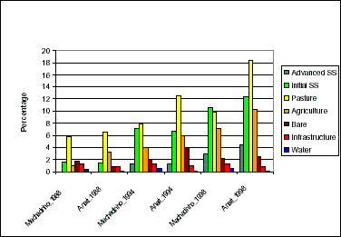
Figure 53 - Percentage of non-forest classes in Machadinho d’Oeste and Vale do Anari in 1988, 1994, and 1998.
Cartographic outputs and field data reveal LULC spatial patterns within the settlements. In Machadinho, small agricultural fields (mainly coffee plantations) predominate at the central portion of the settlement, on both sides of the Machadinho River. The extractive reserves play an important role in maintaining forest cover (Figure 54). Larger patches of pasture occur mainly within the peri-urban area, in the northern portion of the settlement and along main roads MC-06 (east) and MC-07 (north). Patches of initial secondary succession are often associated with these locations (Figure 55).
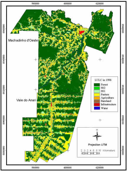
Figure 54 - Machadinho d’Oeste and Vale do Anari - Land Use/Land Cover in 1998.
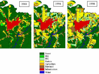
Figure 55 - Pasture conversion in peri-urban areas of Machadinho d’Oeste.
In Anari, larger patches of pasture are found in the south and along the main road. Secondary succession is also associated with these areas. The largest patch of pasture at the southeastern border of the settlement indicates land aggregation processes. To the north, along the boundary with Machadinho, small agricultural fields occur, as well as pasturelands in the intersection of the main road and the feeder roads (Figure 54).