![]()
CHAPTER 4 - LULC DYNAMICS: THE COLONIZATION IMPACT
4.3. Land-Use/Land-Cover (LULC) dynamics
4.3.2. Deforestation, production, and secondary succession: different processes
Different agroecological processes occur in Machadinho and Anari. Deforestation represents the human action to clear the land for production or speculation. Secondary succession is the continuous response of nature through vegetation regrowth whenever humans abandon cleared areas or gaps are formed within forests. The section above showed how LULC changed through time but did not analyze processes of change themselves. This section answers specific questions related to deforestation, production, and succession. What is the pace of deforestation in Machadinho and Anari? Is the deforested land under production or abandonment? How much and when was the deforested land abandoned for succession?
The cartographic result showing land-clearing processes in the study area is illustrated in Figure 56. Areas in southern Anari with no data for 1988 and 1994 represent only 11% of the settlement. It is obvious how the process is associated with the road network, as described further in Section 4.3.4 through buffer analysis. Deforestation before 1988 follows the roads consistently. Colonists in both settlements started to clear their properties as soon as they had access to the land along these paths. The urban area of Machadinho, located in the northeastern limits of the settlement, was also established before 1988. The village of Anari was embedded in a square located between the second and third feeder roads from the north. Deforestation during 1988-1994 and 1994-1998 expanded from the patches cleared before 1988.
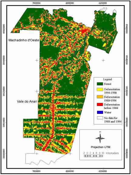
Figure 56 - Machadinho d’Oeste and Vale do Anari - Deforestation until 1998.
Figure 57 illustrates graphically the different paces of deforestation in Machadinho and Anari. Water was not represented (less than 0.5% in both settlements). The period between 1988-1994 showed higher rates of deforestation (13% in Machadinho and 19% in Anari). This is due in part because this period is longer than the period from 1994 to 1998. For the entire period of analysis, Anari's rates of deforestation are always higher than Machadinho's. Moreover, in Machadinho the rates are the same before 1988 and between 1994 and1998 (11%). In Anari, these rates increased from 13% to 16% during the same periods.
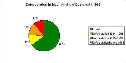
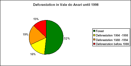
Figure 57 - Percentages of classes of deforestation and forest in Machadinho d’Oeste and Vale do Anari until 1998.
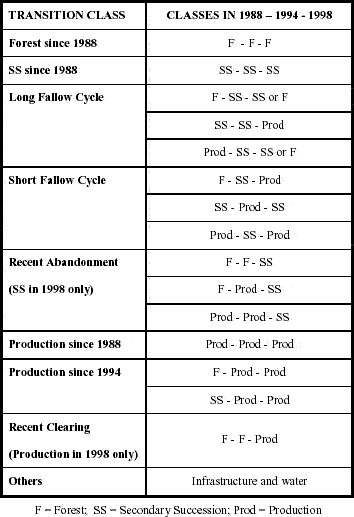
The recoding process to answer questions about secondary succession was more complicated. To answer these questions, the original LULC classifications were recoded to four classes: forest, secondary succession (SS1 and SS2), production (pasture, agriculture, and bareland), and others (infrastructure and water). Then, these classes were combined using transition matrices (ERDAS 1998). Secondary succession in Machadinho and Anari follows cycles of clearing and abandonment of production fields. Thus, these two processes (i.e., expansion of production fields and vegetation regrowth) were used as guidelines for the definition of final transition classes (Table 15).
Table 15 - Definition of transition classes for production and secondary succession in Machadinho d’Oeste and Vale do Anari.
Following deforestation, patches for production since 1988 and 1994 are located closer to roads, in areas cleared for this purpose (Figures 56 and 58). Areas of recent clearing are often located further from roads, as a consequence of the expansion of production activities within the properties. In areas of both settlements, where lots were often not occupied or were abandoned, large areas of recent clearing occur (central-eastern portion of Machadinho and end of eastern feeder roads in Anari). Field observation showed that pasture conversion and land aggregation has occurred in these areas. In Anari, the settlement design facilitates the visual perception of these processes. Other processes occur within areas in succession (i.e., long-fallow cycle, short-fallow cycle, and recent abandonment). They often predominate further from roads, functioning as buffers between areas in production and areas covered by forest (Figure 58).
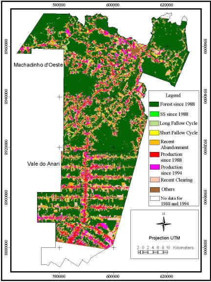
Figure 58 - Machadinho d’Oeste and Vale do Anari - Production and secondary succession until 1998.
Figure 59 illustrates the percentage of the settlements covered by each transition class of production or succession. Machadinho has 5% of its area in long-fallow cycles and 3% in short-fallow cycles. In Anari, these succession areas cover 4% of the settlement each. However, recent abandonment is significantly higher in Anari (13%) than in Machadinho (10%), also indicating a better maintenance of production fields in the latter. Percentages of areas in production since 1988, since 1994, and recently cleared are always higher in Anari (7%, 9%, and 9%, respectively) than in Machadinho (4%, 5%, and 6%, respectively).
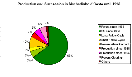
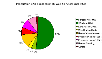
Figure 59 - Percentages of classes of production and secondary succession in Machadinho d’Oeste and Vale do Anari until 1998.