![]()
CHAPTER 4 - LULC DYNAMICS: THE COLONIZATION IMPACT
4.3. Land-Use/Land-Cover (LULC) dynamics
4.3.4. Roads: the path for lot occupation
Access to land is an important variable affecting LULC change in Amazônia. For this reason, distance from roads is often associated with the pace of deforestation and land colonization (Browder and Godfrey 1997, Alves 1999, Alves et al. 1999, Laurance et al. 2001). However, the establishment of road systems in the region is a very complex process, varying regionally and locally. At the regional scale, programs for road building have opened major paths for Amazonian occupation. Towns, rural settlements, and secondary roads have flourished from these roads, making the human footprint visible within the landscape.
The case of Rondônia is singular. As mentioned in Chapter 2, beginning in the early 1970s, the state has been intensively occupied through settlement programs to accommodate migrants from other Brazilian states. The process was accelerated by the building and paving of BR-364, the main road in Rondônia crossing the State from Mato Grosso (southeast) to Acre (northwest). RO-133, the main road crossing Anari from south to north, is a secondary road starting at BR-364, in Jaru. Going further to the north, it reaches the road system of Machadinho (Figures 5 and 6).
This section shows how LULC has changed in distinct and contiguous buffers around roads in Machadinho and Anari. The motivation here is to understand if road system design affected the pattern of LULC change. In this case, the bias caused by reserves increasing the percentage of forest cover within the settlement is attenuated, as the buffers chosen (100 m, 200 m, 400 m, and 800 m) barely reach the reserves' boundaries (Figure 61). So, we can assume that the results are related to LULC change at the property lots.
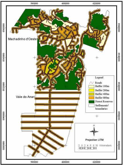
Figure 61 - Machadinho d’Oeste and Vale do Anari - Buffers around roads.
Figure 62 illustrates trends of deforestation until 1998. The spatial pattern varies depending on which buffers are being analyzed. For the 100-meter buffers, the patterns in Machadinho and Anari are very similar, but deforested areas in 1988 are already larger in the latter. Within the 200-meter buffers, the difference begins to be visible. The percentage of area covered by forests or where recent clearing occurred is lower in Anari, indicating the faster process of lot occupation from roads. Within the 400- and 800-meter buffers, the differences become even clearer. Forest cover within the 800-meter buffers is just 25% in Anari and 44% in Machadinho, showing that deforestation processes extend further from roads in Anari.
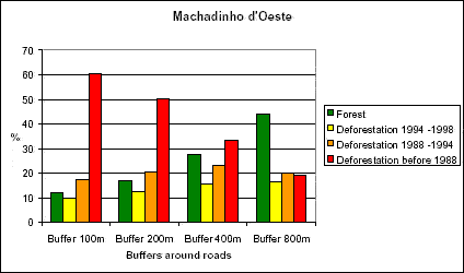
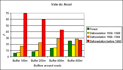
Figure 62 - The route of deforestation around roads in Machadinho d’Oeste and Vale do Anari until 1998.
When analyzing the numbers for production and succession, one can see similar patterns but different magnitudes in Machadinho and Anari. In general, the results for succession (i.e., SS since 1988, long-fallow cycle, short-fallow cycle, and recent abandonment) are about 2% higher in Anari at all distances. Areas in production since 1988 and 1994 are 5% and 3% larger in Anari in all distances, respectively. The main difference between the settlements occurs in areas of recent clearing. They are practically constant in Machadinho in all buffers but increase from 3% to 10% in Anari as they get further from roads. This also indicates that the process of clearing in Anari is more intense than in Machadinho, even after 15 years of colonization.