![]()
CHAPTER 2 - ENVIRONMENTAL AND CULTURAL SETTING: THE OPPORTUNITY FOR A COMPARATIVE STUDY
2.4. The landscape in Machadinho and Anari: background data
2.4.1. Geographic location, boundaries, and settlement architectures
The settlements of Machadinho and Anari are parts of their respective municipalities. Located in northeastern Rondônia (Figures 2, 3 and 4), they are newer colonization initiatives than areas along BR-364 (Cuiabá-Porto Velho Highway). Furthermore, Machadinho and Anari are adjacent to the borders with the states of Amazonas and Mato Grosso, which may offer potentials and constraints for future conservation and development.
Figure 5 shows the areas including both settlements on a subset of a 1998 Landsat TM image. The adjancency of Machadinho and Anari highlights their different architecture, which was appealing for this comparative research. A cartographic representation of these two designs of colonization is presented in Figure 6. It is striking to compare the orthogonal road network and property grid of Anari with the more organic layout of Machadinho. The former had its roads and property lots laid out without regard to topography and the river network. The latter took into account these variables to allocate infrastructure features and communal forest reserves. Causes, consequences, and responses to landscape transformation and land-use preferences within these two localities so close but so distinct are discussed throughout this dissertation.
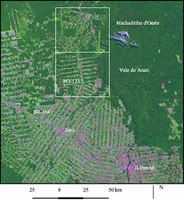
Figure 5 - Landsat TM image from 1998 (bands 3, 4, and 5) showing Machadinho d'Oeste and Vale do Anari distinct designs of colonization.
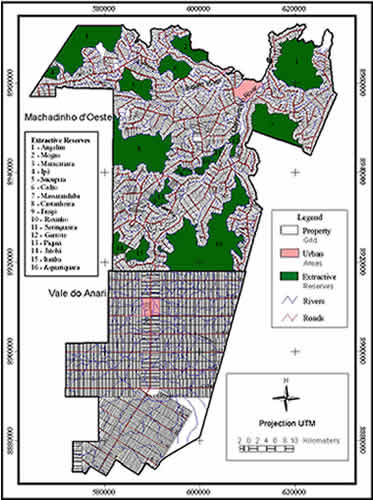
Figure 6 - Machadinho d'Oeste and Vale do Anari - Property Grids, Roads, Rivers, and Extractive Reserves.
2.4.2. Climate
Like the entire Amazon humid region, the State of Rondônia has an equatorial climate, characterized by high precipitation levels, low average annual temperature amplitudes but notable daily temperature amplitudes (Nimer 1989). However, the location of the State in southwestern Amazônia - at approximately 10o south of the Equator - produces some distinct characteristics. Perhaps one of the most important differences is the occurrence of two well-defined seasons, with three dry months during the winter - June, July, and August (Figueroa and Nobre 1990). The climate in the study area follows this pattern, being classified as equatorial hot and humid, with tropical transition. According to Koppen's classification, the climate is Aw, with average monthly temperatures higher than 18oC and a well-defined dry season (Rondônia 1998b).
The lack of meteorological stations with a reliable time series of data in Machadinho or in Anari impedes a more detailed and multi-temporal analysis of climatic variability for the settlements. The closest stations are located in Ariquemes and in the Jaru Biological Reserve, both approximately 80 km from the settlements. The following numbers are derived from analyses of the Jaru data for a period of 20 years (1977 to 1996) and publications about related research projects in Rondônia.
According to Fisch et al. (1998), the average daily solar radiation in Rondônia is 18.3 MJ.m-2.day-1 for the dry season and 17.1 MJ.m-2.day-1 for the wet season (see also Fisch et al. 1997, Gash and Nobre 1997). The annual average precipitation in Machadinho and Anari is 2,016.6 mm (Table 1). A recent study based on data interpolation for the available network of meteorological stations in the State provides a better gauge of the spatial variability of rainfall (Rondônia 1998b). A map from the study shows an increasing variation in precipitation from the south to the north of Rondônia, including Machadinho and Anari in a range of 2,200 mm to 2,500 mm of rainfall per year.
Table 1 - Temperature, precipitation, and wind recorded at the Jaru Biological Reserve, Rondônia, 1977 to 1996.
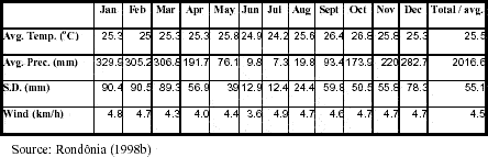
The annual average temperature is 25.5ºC, with the average of maximum temperatures at 32ºC and the average of minimum temperatures at 21ºC (Table 1). The monthly averages of temperature are very constant throughout the year. Similar regularity occurs for the wind speed (average of 4.5 km/h)(Table 1), predominantly from the south from April to October and from NNE/NE from December to March. Monthly averages for air moisture range from 80 to 85%. These characteristics make the monthly potential evapotranspiration also very constant and, with exception for the dry months, the real and potential evapotranspiration are coincident (Shuttleworth 1998). The climatic diagram shows how each season's definition in the study area is a consequence of monthly precipitation variability rather than of temperature oscillations (Figure 7).
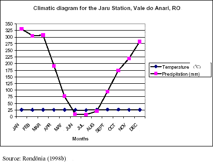
Figure 7 - Climatic diagram for the Jaru Biological Reserve, Rondônia, 1977 to 1996.
2.4.3. Geology
From the geologic perspective, the State of Rondônia is located in the west portion of the Amazonian Craton in a single tectonic-metamorphic-magmatic domain, the Rondonian Province of San Ignacio (1.45 to 1.30Gy) (Rondônia 1998d). In this area, the Paleoproterozoic metamorphic basement is of medium to high degree, being recovered by:
The Mesoproterozoic, Neoproterozoic, Paleozoic, and Mesozoic groups were deposited in successive extensional tectonic events of rifting, being limited by faults and commonly associated with volcanism (Rondônia 1998e).
The area including Machadinho and Anari is basically formed of Cenozoic deposits over the Pre-Rondonian Basement (Paleoproterozoic), the Pre-Rondonian anorogenic suites (Mesoproterozoic), and the Neoproterozoic groups. There are no Paleozoic-Mesozoic sedimentary basins in the area. A brief description of each group or formation, and lithological materials is given below, after compilation from Leal et al. (1978) and Rondônia (1998d, 1998e).
The Pre-Rondonian Basement is formed of gneisses, granulites, anfibolites, migmatites, and calc-silicate rocks. It is a group with medium to high metamorphic degree, constituted more than 1.6 Gy ago (Amazonian Craton), with low permeability and without hydrogeologic interest, except in zones of intense fractures.
The Pre-Rondonian anorogenic suites, formed 1.25 to 1 Gy ago, are plutonic bodies of varied nature (i.e., granites, rapakivi granites, gabbros, and anorthosites). They commonly have low metamorphic degree, low permeability, and low hydrogeologic interest.
The groups Palmeiral-São Lourenço, Prosperança, and Beneficiente, formed approximately 1Gy ago, represent the Neoproterozoic sectors in the study area. Their lithology includes orthoquartizites, arcosian arenites, conglomerates, tuffs, alkaline rocks, and silt or clay horizons. They present a higher hydrogeologic interest and medium to low permeability.
The Cenozoic superficial formations are of the Neogene-Quaternary periods and evolved with the relief as a consequence of tropical meteoric alteration and fluvial dynamics. Because of their detritic nature and the proximity of the sub-surface waters, they frequently present hydrogeologic interest. In general, the Cenozoic formations are 4 to 40 m deep. Two formations occur in the study area. The fluvial terraces and alluvial or colluvial Pleistocene sediments are materials formed by gravel, sand, silt, and clay with different conglomeratic levels but high permeability. The Quaternary-Neogene covertures form other terraces and alteration surfaces showing medium permeability. Some of these features may present laterization.
The relationship of these data to the study of landscape transformation and LULC dynamics in Machadinho and Anari will become clearer after the discussion about their geomorphology, hydrology, and soils, as the potential use of land is directly related to the characteristics of the geological substratum.
2.4.4. Geomorphology and hydrology
Two important concepts have been used to characterize geomorphologic situations in the Amazon: morphostructural unities and morphoclimatic domains (Melo et al. 1978). Morphostructural unities are areas where the geologic conditions created erosive environments under clear control, however without corresponding exactly to the specific sense of geologic provinces (Ab'Sáber 1970). Morphoclimatic domains define areas where the geologic influence were practically nullified by erosion systems affected by the soils' evolution and vegetation, under the control of climatic conditions (Ab'Sáber 1971).
The delimitation of morphostructural unities cited below was based on the homogeneity of relief forms and their relative topographic locations (Melo et al. 1978). Machadinho and Anari are located in three main unities (Figure 8):
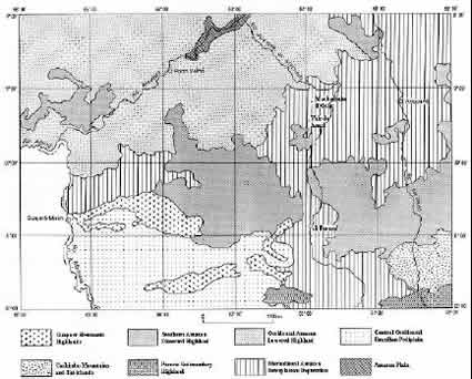
Figure 8 - Morphostructural unities including the study area (adapted from Melo et al.1978).
In terms of the morphoclimatic unities, the study area is very homogeneous, being totally included in Dissected Plateaus and Depressions and Pediplaned Surfaces (Figure 9). The area shows varied relief, including dissected forms in hills, crests, and tabular interfluves, covered by Dense and Open Forest, which minimizes the erosive processes induced by climatic factors.
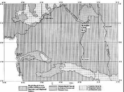
Figure 9 - Morphoclimatic unities including the study area (adapted from Melo et al.1978).
Three main basins are defined for the State of Rondônia: Guaporé, Mamoré, and Madeira. The latter includes the Ji-Paraná or Machado River sub-basin, which is the longest river in the State and drains both Machadinho and Anari settlements, flowing from south to north (Rondônia 1998f). The Machadinho and Anari rivers are both tributaries of the Ji-Paraná or Machado River. They drain an undulated terrain, which varies in elevation from 100 to 450 meters. Within the boundaries of the study area, the Machadinho River flows from the southwest to the northeast. Its main tributary, the Belém River, crosses the northern portion of the settlement. The Anari River flows in the west-east direction, crossing the Anari settlement in its southern portion. The boundary between the settlements coincides with Machadinho and Anari watershed boundaries. Both watersheds have a dendritic drainage pattern with incised valleys. Figure 10 shows the waterways and elevation ranges within the study area through a digital elevation model based on contour lines and the river network.
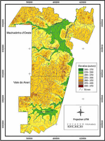
Figure 10 - Machadinho d'Oeste and Vale do Anari - Elevation Classes and Rivers.
2.4.5. Soils
Knowledge about soils should be one of the primary assessments before the establishment of a colonization project. However, detailed studies about this important biophysical variable have been rare before the arrival of colonists in the Amazon (Fearnside 1989). In Machadinho and Anari this pattern persisted. Only regional or exploratory descriptions of soils were available in the early 1980s not allowing the distinction of fertile or infertile soils at the scale of a settlement or property lot (Falesi 1974, Amaral Filho et al. 1978, Cochrane and Sánchez 1982, Sombroek 1984). Even the ecological zoning of the State produced results only at a very coarse scale (1:250,000) (Rondônia 1998g). The most detailed studies about soils at the local scale in the study area are Wittern and Conceição (1982) and, more recently, Bognola and Soares (1999). Their descriptions allow a general characterization about edaphic conditions in Machadinho and Anari. During fieldwork in 1999 and 2000, the characteristics for soil texture and color were confirmed. The paragraphs below summarize the characteristics of seven main soil types present in the area.
It is a mineral soil, not hydromorphic, with a latosolic B-horizon, dystrophic, very deep (>200 cm), cohesive, permeable, well drained and very homogeneous, of very clayish texture, with low levels of total iron, Al2O3/Fe2O3 ratio higher than 7.0 and very acidic. The clay levels remain constant along the profile or increase slightly without, however, indicating a textural B-horizon. The transitions between horizons are diffuse, except from horizon A to B, due to the higher level of organic matter found in the former. Its color varies from brown-yellowish to yellow-brownish, yellow, and brown. The soils with latosolic B-horizon occur in places of mild topography, being therefore easily mechanizable. In their natural state, they are resistant to erosion due to the favorable physical conditions and topography. The main agricultural limitation is related to the low natural fertility, strong acidity, and high levels of exchangeable aluminum (saturation higher than 50%).
It is a mineral soil, with sequence of horizons A, Bw, and C, moderate A-horizon and unclear differentiation between horizons, because of the tenuous contrast and ample transitions between them. It is a clayish soil with very low base saturation, saturation for exchangeable aluminum higher than 50%, low cation exchange capacity in the clay fraction, very acidic, well drained, very porous, very permeable, levels of total iron usually between 7 and 15% and molecular relation Al2O3/Fe2O3 between 3 and 7. The Red-Yellow Latosol Dystrophic is also characterized by its high depth, low clay mobility, which denotes a small textural gradient, low silt/clay ratio, high flocculation degree, low percentage of dispersed clay in water and absence of primary minerals of easy decomposition. The Bw horizon is thick and generally presents colors varying from 4YR to 7,5YR, with values 4 or 5 and chromes 6 or 8. The structure presents porous and firm aspect, breaking in subangular and/or granular blocks. This soil type occurs normally in flat and undulated relief. As with the Yellow Latosol, its main agricultural limitation is related to the low natural fertility, strong acidity, and high levels of exchangeable aluminum in Machadinho and Anari. Both of these soils are used for pasture, annual, and perennial agriculture (coffee).
It is a mineral soil, not hydromorphic, with a latosolic B-horizon, dystrophic, very deep (>200 cm), cohesive, permeable, well drained, very homogeneous, and of very clayish texture. It is very similar to the Red-Yellow Latosol described above, differing mainly in the levels of Fe2O3, which produces a lower Al2O3/Fe2O3 ratio, generally between 1.7 and 2.5. It is a soil with low base saturation and low cation exchange capacity in the clay fraction. The sequence of horizons A, Bw, and C shows poor differentiation. It is also characterized by its low clay mobility, which denotes a small textural gradient, high flocculation degree, and absence of primary minerals of easy decomposition. The morphological characteristics do not vary significantly between horizons, having red-yellow or dark red colors, 5YR and 2.5YR. This Dark Red Latosol occurs normally in flat and undulated relief, associated to the red-yellow latosol and showing similar agricultural limitation and land use.
This soil presents profiles with a sequence of horizons A, Bt, and C. It is deep or medium deep, not hydromorphic, clay of low activity, with moderate A-horizon and textural B-horizon, corresponding to the argillic horizon of the American Soil Taxonomy (USA 1975). The yellow shade has a stronger yellow than 5YR in the first 100 cm of the B-horizon (including BA). The A-horizon, with variable thickness of 10 to 30 cm, presents shades that generally vary from 7,5YR to 10YR. The texture varies from sandy to clay-sandy. The transition to the Bt horizon is generally flat and clear and, eventually, flat and gradual. The Bt horizon presents colors with shade varying from 6YR to 10YR, clayish texture, and the structure is weak to moderate. This soil type occurs in relief varying from mild to strongly undulated and is generally used for pasture in Machadinho and Anari. Its main agricultural limitation is related to the undulated topography, low natural fertility, and high acidity.
It is a mineral soil, with shade 2,5YR or redder and with high base saturation (V > 50%) in the first 100 cm of the B-horizon (including BA). It is generally deep, rarely shallow, with moderate A-horizon and brilliant B-horizon, low clay activity and eutrophic. The soil is well drained and occasionally fairly drained and frequently associated with rock outcrops and, sometimes, with rockiness. The moderate A-horizon is between 10 and 30 cm thick, with shade varying from 2,5YR to 5YR, variable clayish texture and transition to B-horizon, normally flat and clear. The brilliant B-horizon, of variable thickness, presents red colors (2,5YR or redder), with predominantly moderate structure, and angular and subangular blocks. This soil type occurs generally in undulated areas. Land use is mainly coffee plantation and pasture in the study area. The most serious limitations of this soil are consequences of topography and the occurrence of rock outcrops and rockiness. Variations to alfisols also occur within these areas.
It is a mineral soil, not hydromorphic, well drained, deep, with presence of a brilliant B-horizon, clay of low activity immediately below the A-horizon or within the first 50 cm of the B-horizon. Its color is 2,5YR or redder in the first 100 cm of the B-horizon (excluding BA). It originates, in the study area, from the alteration of basic rocks (diabase). Alfisols present clayish texture and are practically free of rockiness. The main variations consist of intermediate profiles looking like the Dark Red Podzolic soil, the difference being detected by higher levels of Fe2O3 (from 15% to 36%). Despite its high fertility, the limitation of this soil for agricultural purposes is related to its low levels of Phosphorus. The susceptibility to erosion is moderate. The erosion is facilitated mainly in areas of undulated or steep topography. The thinner the superficial horizon and bigger the difference of clay content between horizons A and B, the greater the susceptibility to erosion will be. The infiltration and water clamping capacity is good. The limitation for mechanization varies, depending on the relief and rockiness.
It is a mineral soil, with plintic or litoplintic horizon starting at 40 cm, or at 200 cm when immediately below the A or E horizon. It also may underly horizons with a pale color. The shades of this soil type vary considerably and are described in EMBRAPA (1999). The textural B-horizon is present. The alluvial soil has distinct granulometric composition, having low activity clays, slow or moderate permeability and being imperfectly drained. The morphologic features of the underlying layers to the A-horizon may vary a great deal, mainly in function of the water level height and the clay content. The A-horizon, well differentiated, presents variable thickness between 10 and 30 cm. Normally it is sandy, with low to moderate granular structure and with colors varying from 2,5Y to 5Y. The alluvial soil is located in flat areas, occurring also in small depressions, under undulated topography.
2.4.6. Vegetation
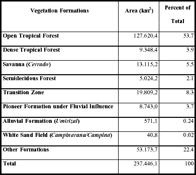
The use of a classification system to address the biocomplexity of the Amazonian vegetation is not an easy task. Depending on the scale of analysis, one or another system may be satisfactory. Some publications have addressed the subject looking for regional differentiations by focusing on the entire Amazon Basin (Pires 1984, Pires and Prance 1985) or a specific State (Rondônia 1998h). According to these classifications, the State of Rondônia encompasses several vegetation formations, although the Tropical Open Forest type predominates (Table 2).
Table 2 - Vegetation formations in the State of Rondônia, Brazilian Amazon (Rondônia 1998h).
Forest formations occurring in Rondônia belong to the so-called tropical rain forests (Richards 1996). Tropical rain forests are the latest in a long line of forest biomes to be heavily altered by mankind. Closed forests of the wetter tropical climates are collectively described as tropical moist forests. Tropical rain forests occur where there is only a short dry season or none (Whitmore 1998). Their main characteristics include:
Machadinho and Anari are areas of relatively high homogeneity in relation to their original vegetation. Their forest formations follow the characteristics above. However, for the purpose of this description, it is more appropriate to focus on the uniqueness of each local vegetation formation. Four main types of tropical rain forests are found in the area, all of them belonging to the severe subtermaxeric bioclimatic sub-region (Barros-Silva et al. 1978, Rondônia 1998h):
The dense forest covers the evidences of basements formed by granites, gneisses, migmatites, and quartzites of several geological formations and of the crystalline basement (Rondônia 1998h). In sub-mountainous areas lower than 600 m it presents, according to soil depth, uniform cover or emergent trees. Its canopy is continuous and closed. Trees dominate the canopy, but they can also occur associated with palms in open valleys and lianas in hillsides and closed valleys (Barros-Silva et al. 1978). It has small spatial distribution in the study area, generally associated with more dynamic topography, such as the northeastern and southeastern portions of Machadinho and the north-central portion of Anari.
This type of forest grows over shallow and poorly drained hydromorphic soils, in flat terrain up to 100 m high and in floodplains. The alluvial open forest has medium height, up to 30 m, and less than 5% of deciduous species. The canopy may be uniform with occasional emergent species. The understory is usually dense, with dominance of bushes and herbs. The density may be higher than 600 trees per hectare. In dystrophic soils, the density is higher but the average height of the trees decreases (Rondônia 1998h). The dominant physiognomy is the open forest with palms, such as the forest covering terraces of the Machadinho River. In such sites, trees are often covered by herbaceous lianas, giving the false impression of a liana forest (Barros-Silva et al. 1978).
These two forest types differ only in relation to their substratum (dissected or undulated relief). They are the most representative vegetation formation in both Machadinho and Anari, covering more than 80% of the entire study area before the colonization process took place. The dominant landscape is the open tropical forest with palms covering distinct topographic situations over the crystalline basement (Rondônia 1998h). The dominant soil is the red-yellow podzolic (ultisol), where forests of emergent trees, uniform canopy, bamboo, and lianas also occur. The understory in the forests with palms varies from open to medium, and, from medium to dense in the forests with lianas and forest with bamboos (Barros-Silva et al. 1978). In Machadinho, the sub-montane open tropical forest over undulated relief dominates almost the entire settlement, except at the sources of the Ananas River and in areas to the east of the Machadinho River, where the relief is dissected. In Anari, the sub-montane open forest over dissected relief is more spatially representative, dominating the western and southern portions of the settlement.
2.4.7. Fauna
Landscape fragmentation and its consequences on Amazonian animal habitats have been discussed in several works (Prance and Lovejoy 1985, Dale et al. Relating 1994, Laurance et al. 1997). However, there are no data available on fauna resources for the study area. Because of the importance of this biological component on Rondonian landscapes, some comments may be appropriate.
The most recent faunal study covering the entire State is the diagnostic prepared for the second approximation of the socioeconomic-ecological zoning of Rondônia (Rondônia 1998c). Field data was collected for the occurrence of several groups, such as bees, disease vectors, agricultural pests, ictiofauna, herpetofauna, avifauna, and mastofauna. Trying to delimit zoogeographic zones for the State, the authors used the latter three groups as indicators of relatively homogeneous habitats. According to their classification, both Machadinho and Anari belong to a zoogeographic zone of high biodiversity, including endemic, endangered, and threatened species.
The settlements studied differ in terms of conservation management. Machadinho includes sixteen Extractive Reserves in distinct ecological sectors encompassing 33% of its territory. Anari design did not incorporate reserves. In this case, preservation depends solely on a federal rule, stating that 50% of each property lot should be maintained with its forest cover. Ecological consequences of these different strategies are addressed in the next chapters, through the study of LULC dynamics and landscape change.