![]()
CHAPTER 6 - BEYOND THE METRICS: HUMAN DIMENSIONS OF LANDSCAPE CHANGE
6.2. The structure of rules and incentives affecting land-use in Machadinho and Anari
The occupation of the Brazilian Amazon is taking place through several mechanisms, including governmental and private programs, and spontaneous colonization. In all cases, local population growth occurs, mainly through migration during the settlements' implementation phase. Different levels of land-use decision making are involved. International, national, regional, and local incentives, rules, and policies affect the process, the environmental outcomes, as well as the socioeconomic conditions present in that portion of the country of relatively difficult access. Attributes of the local community and biophysical attributes of landscapes set the scenarios for individual decisions. Figure 83 illustrates a multi-tiered framework to address factors affecting landscape change. The approach is based on the Institution Analysis and Development framework (Ostrom 1997), where actors within an action arena interact and adapt according to environmental attributes, community attributes, and rules-in-use. From the operational standpoint, the analysis of these processes within the research in Rondônia was derived from a multi-temporal and multi-spatial approach about the study area and its actors (Figure 84).
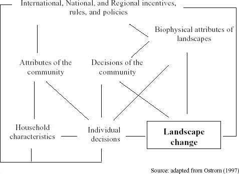
Figure 83 - Hierarchical approach defining landscape change in Machadinho d’Oeste and Vale do Anari.
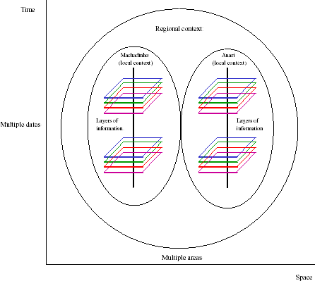
Figure 84 - Conceptual approach for analyses of the human dimensions of landscape change.
The first step was the choice of boundaries. As stated in Ostrom et al. (1994), it is not easy to distinguish where one situation ends and the next one begins. However, for analytical purposes it is essential to define boundaries in space and time in order to focus on specific events. This chapter, as the rest of the dissertation, focuses on the settlements of Machadinho and Anari, considering their administrative boundaries as implemented by INCRA. The time frame went back to the early 1980s to ensure a broader context about processes and patterns of interactions occurring within the study area.
Figure 85 illustrates a sequence of events occurring at national, regional, and local contexts during Machadinho and Anari implementation and consolidation phases. These events affected the action arena and the actors' decision-making processes through time, leading to social and environmental outcomes. For the purpose of this analysis, the so-called actors (i.e., loggers and settlers in Anari, and loggers, settlers, and rubber tappers in Machadinho) are the direct agents of landscape change. They take actions concerning the land, clearing areas, managing natural resources, and developing production systems. Figure 86 illustrates the main actions taken by settlers, rubber tappers, and loggers on private properties and communal reserves in Machadinho and Anari.
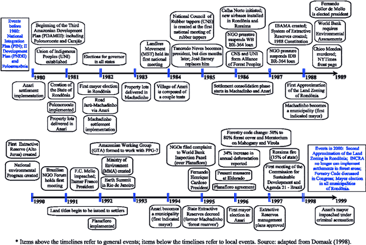
Figure 85 - Timeline of selected events affecting Machadinho d’Oeste and Vale Anari.
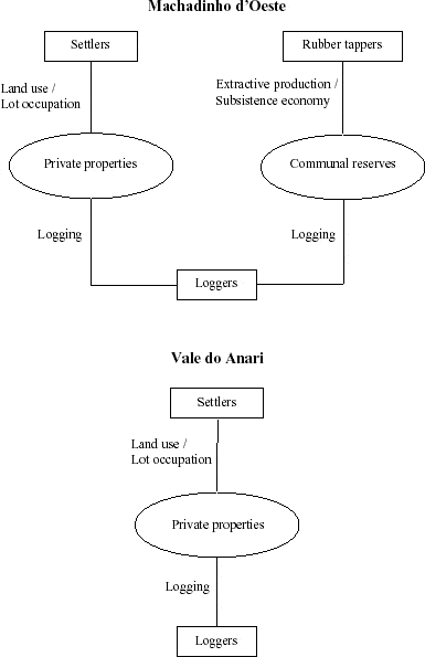
Figure 86 - Actors and actions in Machadinho d’Oeste and Vale do Anari.
Settlers had access to land through elimination and classification criteria based on socioeconomic assets and carried out by INCRA. The process of choice of property lots was somewhat chaotic and sometimes involved corruption. Conflict resolution between new settlers and previous occupants of the land (posseiros) was in general mediated by INCRA, but often involved violence. The action of grileiros also caused problems for settlers. They often took over the land from weakened households. The situation involved persuasion (i.e., convincing illiterate settlers that they did not have the right to use the lot) or violence (i.e., expelling families of settlers under threat of murder). In the early 1980s, the general picture in Machadinho and Anari included families of settlers from south and southeast Brazil coping with their environmental and social opportunities and constraints in searching for a better life at an Amazonian agroecological frontier.
Rubber tappers have lived in the study area since the late 1800s. They are mostly descendants of northeastern migrants to Rondônia during the rubber boom. The saga of rubber tappers in the Amazon has been extensively described and will not be discussed in detail here. One of the most important changes in their function as social actors occurred recently with the creation of extractive reserves throughout the Amazon (Allegretti 1989, Miranda et al. 1990, Anderson 1992). Specifically, they have played a central role in Machadinho, where extractive reserves were included within the settlement design. The right to use natural resources within the reserves is restricted to rubber tappers. They also had the opportunity to apply for property lots. In fact, some reserves have rubber tappers living in the reserves' surroundings. In this case, the distinction between these two groups of actors (i.e., settlers and rubber tappers) is somewhat interrelated. Besides this specific situation, they inhabit the reserves and make their living through a subsistence economy.
Loggers represent another important group of actors at rural settlements in Amazônia (Browder 1986, Almeida and Uhl 1995). They often exploit timber resources in all phases of a settlement according to the availability of economic species and rules of access to forests. Illegal operations are frequent, mainly during early stages of land occupation. Loggers extract timber from unclaimed lands without permission, but also from claimed lands through invasion or accords with local governmental organizations, settlers, and, more recently, rubber tappers. The action of loggers has been often necessary to provide access for the settlers to their lots through road building. Also, loggers have cleared initial portions of the lot where settlers develop their production systems. The interactions between settlers and loggers have been often based on opportunistic actions by the latter, which quickly exploit the most valuable species without concern for environmental or social impacts. Recently, efforts have been made by the Brazilian government and IBAMA to set up clear policies for timber extraction in the Amazon, mainly through the release of legal permissions consonant with management plans. However, these initiatives are far from being effectively enforced.
Processes of landscape transformation caused by human occupation in Machadinho and Anari are discussed throughout this dissertation. In order to provide a better understanding about the trajectories of each colonization project, the following sections describe historical aspects associated with their implementation and the structure of rules and incentives for each actor taking direct actions over the landscape and its environmental resources.
6.2.1. Anari: a ’rapid settlement project’
The implementation phase of Anari started between 1980 and 1982. The settlement was part of a cooperative program between the federal agency INCRA and the State government of Rondônia with the goal of settling 16,000 families. The strategy was called 'rapid settlement project' (projeto de assentamento rápido), and carried out as an emergency plan. The program succeeded in settling 12,315 households in approximately 800,000 ha in 11 tracts throughout Rondônia (Rondônia 1996d). INCRA was responsible for carring out part of the implementation phase (including land demarcation and distribution) and the emancipation phase, when land titles were issued. The State government was supposed to provide basic infrastructure and maintenance services. Thus, INCRA delivered the settlements with just the main dirt road and partially opened feeder trails to provide access to the lots.
Anari was the largest settlement within the ’rapid project’ strategy, encompassing an area of 1,246 km2. Approximately 2,000 families were settled in lots of 50 ha each (Rondônia 1996d). Anari maintained the blueprint of a fishbone-like design, with a main road crossing the settlement and secondary feeder roads crossing perpendicularly every four kilometers from the main village (Figures 5 and 6). However, since the State government failed to fulfill its commitment to improve the road network, the poorly opened feeder trails provided difficult access to the parcels. The lack of an improved road system created an extra burden to settlers, who had to open the way to their properties. By that time, families were settled at their lots without water, electricity, roads, or assistance for beginning their life at the frontier. The main village had only a few houses and no available infrastructure.
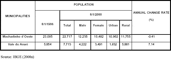
Another infrastructure problem that narrowed the options regarding the use of rural properties in Anari by settlers was the lack of a center with basic services. Improvements to the village and to the main road took place only with the implementation of the Machadinho settlement project years later (1982-1984). Health problems, such as malaria strongly affected the labor force available in the area during the early stages of the settlement (Rondônia 1996b). Land abandonment was frequent, creating opportunities for speculators to aggregate underused lots by clearing them and converting the land to pasture. Although showing an increasing trend during the last five years, the population of Anari after twenty years of colonization consisted of 7,713 inhabitants, 76% of them still living in the rural area (Table 41) (IBGE 2000a).
Table 41 - Population in Machadinho d’Oeste and Vale do Anari.
Besides all the constraints on the establishment of properties, land use was also limited by federal legislation, in which 50% of the parcel was to be kept intact as private forest reserves. In addition, settlers were restrained from bank loans due to lack of information within their settlement, difficult access to the closest urban centers where banks were located (i.e., about 80 km of poorly maintained dirt roads), and lack of political organizations that could mediate the negotiation. At the time, a different scenario was taking place in Machadinho.
6.2.1. Machadinho: a better design for settlement projects in the Amazon?
Machadinho was implemented between 1982 and 1984 by INCRA as part of a broader development project funded by the World Bank (POLONOROESTE). The original settlement had an area of 2,090 km2 with 2,934 plots designated for landless small farmers. Despite a similar demand to accommodate migrants in Rondônia, the settlement project (projeto de assentamento - PA) Machadinho, along with two other projects - Cujubim and Urupá - represented an alternative design for rural development, which was meant to overcome past failures (Fearnside 1986, 1989).
As part of this endeavor, Machadinho was a settlement project gifted with distinct architectural and institutional designs in comparison to former initiatives throughout the Amazon. Property lots were defined according to watershed topographic features. The road network was constructed along the ridges, facilitating its maintenance and allowing water access to almost all settlers by including a stream in the rear of the property. The topography-oriented design was combined with an alternative institutional design related to forest reserves (Figure 6). The settlement included 16 communal reserves of different sizes, which encompassed 33% of the total settlement area (685 km2) with right-of-use to rubber tappers (Table 16). The reserves were created to achieve ecological, economic, and social goals. Ecologically, larger forest areas could be preserved under lower levels of fragmentation. Economically, by ensuring forest preservation within the communal reserves, settlers would be allowed to use the full extent of their properties with no legal constraint. Socially, the rubber tappers who had lived in 90 extractive locations (colocações) distributed throughout the settlement would have their livelihood ensured by the communal reserves.
In addition, settlers counted on a privileged treatment in terms of infrastructure, including gravel roads throughout the rural area. INCRA built 725 km of road network in Machadinho, divided into four hierarchical levels: 11 km of four main roads (access roads), 105 km of feeder roads level 1 (collect roads), 314 km of feeder roads level 2 (feeder roads), and 295 km of feeder roads level 3 (penetration roads). These figures represent the best-served road structure of all regular settlement projects in Rondônia up to this date in both gross and per area of road footage. INCRA also provided basic services such as one school, one health center, electric and water pipe systems, and an airport (59 ha) within the 2,000 ha urban center. In the rural area, 10 secondary villages (953 ha), 44 schools, 547 houses, 60 wells, and 5 health centers were built (Miranda and Mattos 1993). Agencies related to agriculture and environmental activities were set in the area to provide technical assistance to the farmers (e.g., INCRA, EMATER, EMBRAPA, CEPLAC, IDARON, IBAMA, SEDAM). In particular, the extension agency EMATER supported the creation of associations in different tracts throughout the settlement.
The institutional arrangement derived from Machadinho's design led to the existence of three major groups as direct agents of landscape transformation (i.e., settlers, rubber tappers, and loggers). The settler population came mostly from the States of Paraná and Minas Gerais and encompassed 2,934 immigrant households. They occupied 67% of the area (1,415 km2) in private lots of about 44 ha. The outcomes in terms of LULC change at the properties were described in Chapter 4.
The communal reserves house a total of 401 individuals. The reserves are property of the State with the residents having the right-of-use. They are organized in a local rubber tapper association, which is linked to state and federal councils. Their income is centered on the production and commercialization of raw rubber and based on subsistence economy (i.e., slash-and-burn agriculture, forestry, game, and, more recently, small coffee plantations). In 1995, the reserves were decreed State Extractive Reserves, allowing communities to make their own management plans, which may include sustainable logging operations. Just one reserve has a different status with use restricted to the State (Floresta de Rendimento) (Olmos et al. 1999).
As mentioned before, loggers also play an important role in modifying forest structure and in clearing forests in Machadinho. Chapter 2 briefly describes the production systems associated with settlers, rubber tappers, and loggers. The sections below discuss the incentives and constraints for each group affecting landscape within the study area.