![]()
CHAPTER 5 - LANDSCAPE CHANGE DESCRIBED BY SELECTED METRICS
5.4. Spatial pattern and process in Machadinho and Anari: metrics and trends
The following sections present the results for landscape, class, and patch metrics.
5.4.1. Landscape: a broad comparison between the study sites
Landscape metrics should be considered with caution, as they average values obtained for patches and classes within the landscape. However, when comparing two distinct architectural designs of colonization in the Amazon on a multi-temporal basis, an overview of these metrics can provide a first indication about landscape structure and change. The following paragraphs comment the results presented in Table 27.
Table 27 - Computed metrics for Machadinho dOeste and Vale do Anari landscapes in 1988, 1994, and 1998.
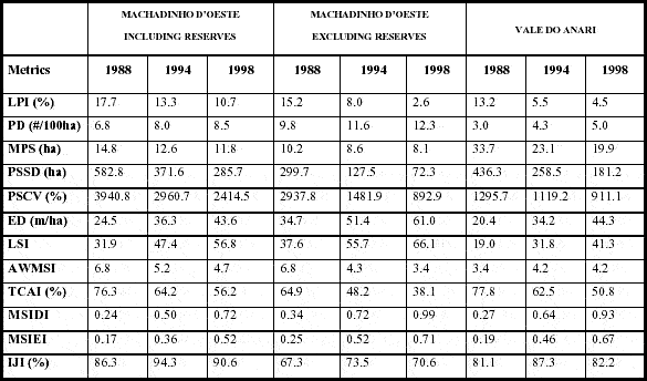
The Largest Patch Index (LPI) quantifies landscape composition through the percentage of total landscape area encompassed by the largest patch. LPI has been widely used as an indicator of landscape fragmentation. LPI decreases in both settlements as deforested areas expand through time. In Anari, LPI decreases threefold, while in Machadinho it decreases less than twofold. However, when excluding the communal reserves from Machadinho's design, LPI decreases abruptly to 2.6% of the landscape.
Patch density, patch size, and variability metrics also serve as indicators of fragmentation processes within landscapes. Patch density (PD) is greater in Machadinho in all dates, but increases at a lower rate than in Anari. Mean Patch Size (MPS) is larger in Anari, but much more stable in Machadinho through time. As both PD and MPS are functions of the number of patches and total landscape area, these results are somewhat redundant and indeed show the same process. MPS is more informative when interpreted together with a measurement of dispersion. Patch Size Standard Deviation (PSSD) and Patch Size Coefficient of Variation (PSCV) are variability metrics and indicate aspects related to landscape heterogeneity. Thus, landscapes with greater PSSD and PSCV are more heterogeneous and landscapes with lower PSSD and PSCV are more uniform. For the three cases being analyzed, PSSD and PSCV tend to decrease over time and particularly at a higher rate in Machadinho when excluding the reserves. This tendency is largely influenced by values for PSSD and PSCV for classes, as will be shown below.
Another group of indicators of landscape fragmentation is represented by edge metrics. Edge Density (ED) was chosen for comparative purposes between Machadinho and Anari because Total Edge (TE) is directly affected by the size of landscapes under analysis. ED is a measurement of landscape configuration with applications to the study of edge effects. Values for ED in Machadinho, including reserves, and in Anari are roughly similar in all dates. When excluding the reserves, ED in Machadinho is much greater in all dates.
Shape metrics are as important as patch size metrics for the understanding of landscape configuration (Milne 1988). Two shape metrics were used for landscapes within the study area, both derived from comparisons to a circular shape at the patch level (Appendix 2). The Landscape Shape Index (LSI) increases over time in all cases, although it has lower values in Anari and higher values in Machadinho when excluding reserves. In Machadinho, the Area Weighted Mean Shape Index (AWMSI) decreases from 1988 to 1998. It starts with the same value with or without reserves and decreases more abruptly when reserves are not included for the calculations. In Anari, AWMSI increases from 1988 to 1994 and is stable from 1994 to 1998.
Core area was defined as the area within a patch beyond the distance of 90 m from its edge. Also important for the study of edge effects, core area metrics were selected for the research in Rondônia. These metrics indicate both aspects related to composition and configuration. For landscapes, the Total Core Area Index (TCAI) was used. It quantifies core area for the entire landscape as a percentage of total landscape area. TCAI decreases 20% in Machadinho over time. When excluding reserves, TCAI decreases 27% during the period of study, as it does in Anari.
Diversity metrics quantify landscape composition by measuring richness and evenness of patch types. Richness refers to the number of patch types and evenness refers to the distribution of area among different types. The Modified Simpson's Diversity Index (MSIDI) was used to reflect differences in patch richness over time. The Modified Simpson's Evenness Index (MSIEI) quantified evenness among the landscapes. Although MSIDI and MISEI increase approximately threefold for all landscapes under analysis over time, Machadinho is less diverse and less even in all dates. When excluding reserves from the analysis, diversity metrics in Machadinho are closer to values observed in Anari.
The nterspersion and Juxtaposition Index (IJI) measures how intermixed patch types are within a landscape and, therefore, are related to configuration. IJI is calculated in percentage units and approaches 100% when all classes are equally adjacent to all other classes. Machadinho shows higher IJI values in all dates, followed by the less interspersed landscapes of Anari and Machadinho without reserves. An interesting finding is a higher IJI value for all cases in 1994. The next section presents the results for metrics calculated at the class level and provides a more detailed perspective about pattern and processes within landscapes in Machadinho and Anari.
5.4.2. Class: understanding LULC change through spatial metrics
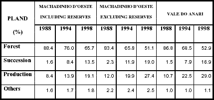
Selected metrics were computed for classes within Machadinho and Anari landscapes. Results for forest are particularly emphasized in this section, as they play an important role in defining landscape structure and fragmentation within the study area. Percentage of Landscape (PLAND) and Largest Patch Index (LPI) provide results in terms of percentage of total landscape covered by all patches of a class and by the largest patch of a class, respectively (Appendix 2). As pointed out in Chapter 4, PLAND of forest in Machadinho dropped from 88.4% in 1988 to 65.7% in 1998, while in Anari these values were 86.8% and 52.9%, respectively. When excluding the communal reserves from the analysis, Machadinho shows the same rate of deforestation as Anari. Areas in succession increased about 11.9% in Machadinho, 16.7% if excluding the reserves, and 15.4% in Anari during the period of study. For production areas, these figures were 10.7%, 15.4%, and 18.3%, respectively. PLAND for other areas (water and built-up land) stayed stable over time (Table 28). These trajectories were also discussed in Chapter 4 and complemented by property-based data analysis, although a more disaggregated classification system was used at that point.
Table 28 - Percentage of landscape (PLAND) for each class in Machadinho dOeste and Vale do Anari in 1988, 1994, and 1998.
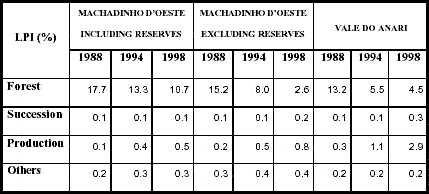
The examination of LPI for each class allows a better understanding about the behavior of this metric than when analyzed for the entire landscape (Table 29). LPI for forest decreases with time down to 10.7% in Machadinho, 4.5% in Anari, and only 2.6% in Machadinho without reserves. Anari shows consistently higher values of LPI for succession and production areas in all dates.
Table 29 - Largest Patch Index (LPI) for each class in Machadinho dOeste and Vale do Anari in 1988, 1994, and 1998.
Patch density, patch size, and variability metrics were also calculated for landscape classes (Tables 30 to 33). Patch Density (PD) of forest increases more than 2.5 times in Anari during the period of study. In Machadinho, it increases at a much lower rate. Higher values of PD are observed for forest in Machadinho when excluding reserves. PD of areas in succession increases at a similar rate for all cases although its values are higher in Machadinho, particularly when excluding reserves. In Machadinho, PD of areas in production decreases from 1988 to 1994 and increases from 1994 to 1998. In Anari, it just increases over time (Table 30).
Table 30 - Patch Density (PD) for each class in Machadinho dOeste and Vale do Anari in 1988, 1994, and 1998.
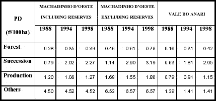
Table 31 - Mean Patch Size (MPS) for each class in Machadinho dOeste and Vale do Anari in 1988, 1994, and 1998.
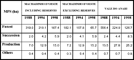
Table 32 - Patch Size Standard Deviation (PSSD) for each class in Machadinho dOeste and Vale do Anari in 1988, 1994, and 1998.
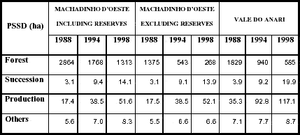
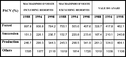
Table 33 - Patch Size Coefficient of Variation (PSCV) for each class in Machadinho dOeste and Vale do Anari in 1988, 1994, and 1998.
In Machadinho, Mean Patch Size (MPS) of forest fragments dropped from 319.0 ha (n=592) in 1988, to 219.1 ha (n=741) in 1994, and to 167.4 ha (n=838) in 1998. In Anari, these metrics were 556.4 ha (n=170) in 1988, 224.9 ha (n=332) in 1994, and 126.7 ha (n=455) in 1998. In Machadinho without reserves, MPS of forest is considerably smaller in all dates (Table 31). Values of MPS for succession areas, production areas, and other features are unaffected by the exclusion of forest reserves. MPS of succession areas in both landscapes are similar in 1988 and 1994, but larger in Anari in 1998. MPS of areas in production are always larger in Anari.
Patch Size Standard Deviation (PSSD) and Patch Size Coefficient of Variation (PSCV) were also computed for landscape classes (Tables 32 and 33). In succession areas, production areas, and other features, PSSD and PSCV values are also unaffected by the exclusion of forest reserves. PSSD of forest decreases in all cases. In Machadinho, the exclusion of reserves from the analysis causes an abrupt drop in PSSD values for forest. PSSD of succession areas is greater in Anari in 1998, while PSSD of production areas is always greater in all dates (Table 32). PSCV of forest in Machadinho decreases slowly over time but rapidly if reserves are excluded. In Anari, PSCV of forest increases from 1988 to 1998 (Table 33).
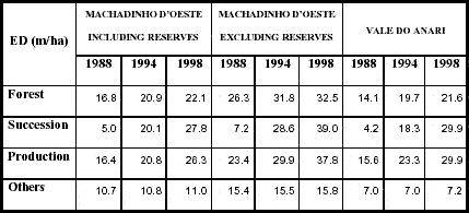
Results for Edge Density (ED) of forest are roughly similar for all dates in Machadinho and Anari. When excluding the reserves in Machadinho, PD of forest is greater. Similar trends were found for ED of succession and production classes. In all cases, PD increases over time (Table 34).
Table 34 - Edge Density (ED) for each class in Machadinho dOeste and Vale do Anari in 1988, 1994, and 1998.
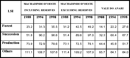
Landscape Shape Index (LSI) and Area Weighted Mean Shape Index (AWMSI) were also computed for all classes. As done for landscapes, these metrics quantify the amount of edge present in a class relative to what would be present in a class of the same size but with a circular shape. In other terms, these metrics provide a relative measurement of shape complexity. The particularity about AWMSI is that larger patches are weighted more heavily than smaller patches in calculating the average patch shape (Appendix 2). LSI increased for all classes in Machadinho and Anari over time. LSI of forest increased 1.5 times in Machadinho and twofold in Anari. However, values in Anari are lower than in Machadinho in all dates. The highest LSI values for forest were found for Machadinho without the reserves. LSI results for succession, production, and other features were unaffected in Machadinho when excluding reserves from the analysis. In general, Machadinho has higher values of LSI for these classes, but both landscapes present the similar ascendant trend (Table 35).
Table 35 - Landscape Shape Index (LSI) for each class in Machadinho dOeste and Vale do Anari in 1988, 1994, and 1998.
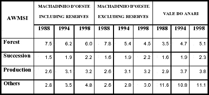
AWMSI results reveal other interesting findings (Table 36). AWMSI of forest shows opposite trends within the two landscapes, decreasing in Machadinho and increasing in Anari over time. When Machadinho reserves are excluded, AWMSI also decreases, but at a higher rate than when the landscape is complete. AWMSI of succession areas increases similarly in both landscapes. Production areas otherwise have higher AWMSI values in Anari in all dates. AWMSI results for other features (water and built-up land) are notably stable and higher in Anari, while they increase in Machadinho during the period of study.
Table 36 - Area Weighted Mean Shape Index (AWMSI) for each class in Machadinho dOeste and Vale do Anari in 1988, 1994, and 1998.
Opposite trends were found for the Mean Core Area Index (MCAI) of forest. It increases in Machadinho and decreases in Anari over time. MCAI of succession and production areas increases in all cases during the period of study and is always higher in Anari (Table 37).
Table 37 - Mean Core Area Index (MCAI) for each class in Machadinho dOeste and Vale do Anari in 1988, 1994, and 1998.

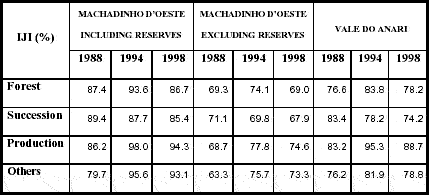
The last metric calculated for classes within Machadinho and Anari landscapes was the Interspersion and Juxtaposition Index (IJI)(Table 38). This metric defines how class patches are located in relation to other patches of the same class and to patches of other classes within the landscape. IJI of forest is greater in Machadinho in all dates, followed by Anari and Machadinho without reserves. In all cases, values of IJI of forest are similar in 1988 and 1998, peaking in 1994. IJI of succession areas decreases 4% in Machadinho, 3.2% in Machadinho without the reserves, and 9.2% in Anari. IJI of production areas also increase in 1994 in all cases, decreasing in 1998 but at a higher level than in 1988. A similar trend occurs for other features (water and built-up land). The next section describes the results found for patch metrics.
Table 38 - Interspersion and Juxtaposition Index (IJI) for each class in Machadinho dOeste and Vale do Anari in 1988, 1994, and 1998.
5.4.3. Patch: polygon-based descriptive statistics
Patch-based metrics were also computed for Machadinho and Anari landscapes. The paragraphs below present results for area of patches (AREA), perimeter of patches (PERIM), shape index of patches (SHAPE), and fractal dimension of patches (FRACT) (Appendix 2; Figures 71 - 82). Results for forest, succession, and production patches are emphasized. Patches of other features (i.e., water and infrastructure features including roads and urban areas) show little variation over time and are not discussed.
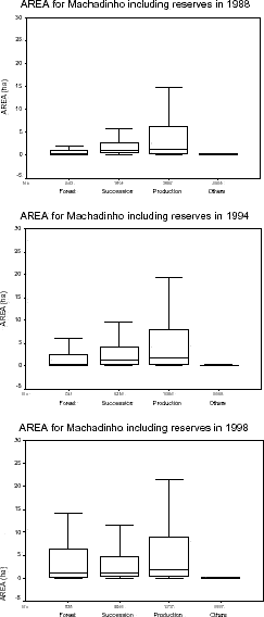
Figure 71 - Patch area distribution for Machadinho dOeste including reserves in 1988, 1994, and 1998.
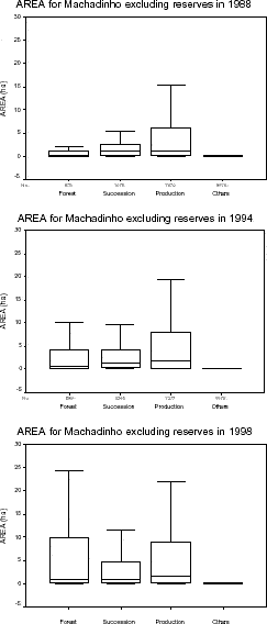
Figure 72 - Patch area distribution for Machadinho dOeste excluding reserves in 1988, 1994, and 1998.
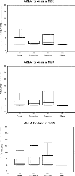
Figure 73 - Patch area distribution for Vale do Anari in 1988, 1994, and 1998.
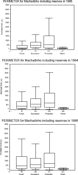
Figure 74 - Patch perimeter distribution for Machadinho dOeste including reserves in 1988, 1994, and 1998.
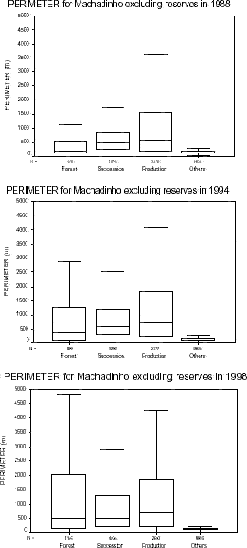
Figure 75 - Patch perimeter distribution for Machadinho dOeste excluding reserves in 1988, 1994, and 1998.
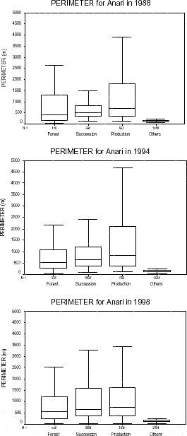
Figure 76 - Patch perimeter distribution for Vale do Anari in 1988, 1994, and 1998.
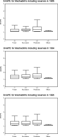
Figure 77 - Patch shape distribution for Machadinho dOeste including reserves in 1988, 1994, and 1998.
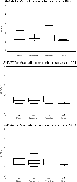
Figure 78 - Patch shape distribution for Machadinho dOeste excluding reserves in 1988, 1994, and 1998.
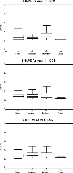
Figure 79 - Patch shape distribution for Vale do Anari in 1988, 1994, and 1998.
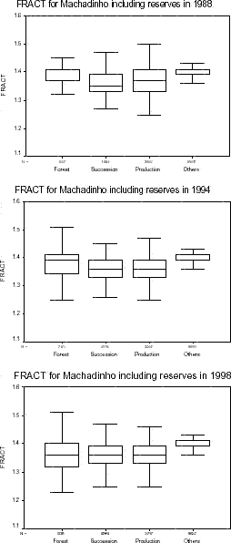
Figure 80 - Patch fractal dimension distribution for Machadinho dOeste including reserves in 1988, 1994, and 1998.
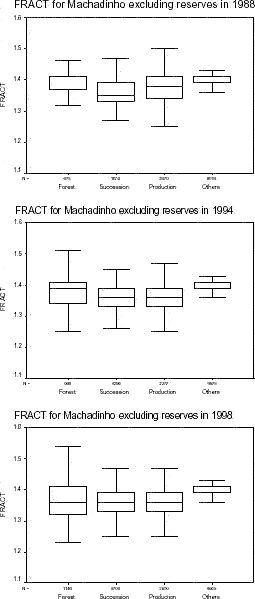
Figure 81 - Patch fractal dimension distribution for Machadinho dOeste excluding reserves in 1988, 1994, and 1998.
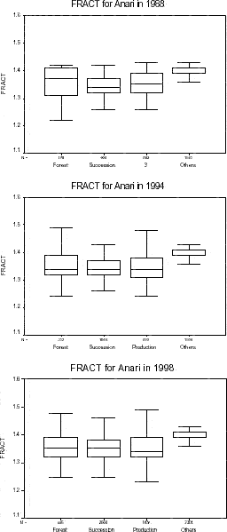
Figure 82 - Patch fractal dimension distribution for Vale do Anari in 1988, 1994, and 1998.
For the patch-based analysis, it is important to remember that the box within boxplots represents the interquartile range and contains 50% of all values. The line crossing the box is the median. Whiskers represent the highest and lowest values, excluding outliers. Unfortunately, for the sake of producing readable and comparable graphs for all dates and cases of study, extremes and outliers were hidden from the output. This weakens the analysis for particular questions but allows a better picture of the majority of values within the statistical population (Ott 1993).
Values for area of patches are presented in Figures 71, 72, and 73. The interquartile range for patches of forest increases in Machadinho over time, either including or excluding reserves. In Anari, this interval is more stable through time although greater in 1988. The distribution of values for area of succession and production patches is similar in both cases analyzed for Machadinho in all dates, with the interquartile ranges for both classes tending to increase over time. In Anari, the distribution of successional areas is also similar to Machadinho in 1988 and 1994. In 1998, the interquartile range and highest value are slightly greater. The range and highest value of production areas in Anari are slightly greater than in Machadinho in 1988, distinctively greater in 1994, and slightly smaller in 1998.
The interquartile range for perimeter of forest patches increases in Machadinho during the period of study. In Anari, it decreases from 1988 to 1994 and slightly increases in 1998. The range is obviously greater in Anari in 1988, similar but with higher median in 1994, and smaller but with similar median in 1998. Including or excluding reserves do not affect results for perimeter of succession or production patches in Machadinho. In both cases, the range increases slightly in 1994 and remains stable in 1998. In Anari, the median of perimeter of succession patches is often higher than in Machadinho, while the interquartile range is greater only in 1998. For production areas, the median and range are greater in Anari than in Machadinho in 1988 and 1994. In 1998, the range is smaller in Anari and the median is equivalent in both settlements (Figures 74, 75, and 76).
Some points deserve consideration for the shape index and fractal dimension, as shown in figures 77 to 82. The interquartile range of the shape index for forest patches is slightly greater in Machadinho when excluding reserves from the analysis. The presence of reserves does not affect values for succession and production patches. In Anari, the range for forest is greater than in Machadinho in 1988, but smaller in 1994 and 1998. The median is also smaller in 1998. Shape index for succession patches in Anari has similar ranges and medians as Machadinho in all dates. For production areas, the shape index in Anari is similar to Machadinho in 1988 and 1994. In 1998, its range and median are smaller.
Fractal dimension measures shape complexity for each patch within the landscape. It ranges from 1 to 2, with 1 meaning Euclidian geometric shapes such as circles and squares, and 2 meaning a very complex patch shape. In Machadinho, the median fractal dimension of forest patches decreases as its range increases over time. When excluding reserves, the trend is similar, although the upper quartile and highest values are greater in 1998. In Anari, the median for forest patches decreases from 1988 to 1994 but increases slightly in 1998. The interquartile range also decreases from 1988 to 1994 and remains stable in 1998. Fractal dimension of patches of succession and production areas are unaffected when excluding reserves from the analysis in Machadinho. The median slightly increases for succession areas from 1988 to 1994 and stays stable in 1998. In Anari, values for fractal dimension of succession patches are very similar for all dates. The median and range of fractal dimension of production patches decreases in 1994 in Machadinho and remains equivalent in 1998. A similar trend was found for Anari although the median values are lower.