![]()
CHAPTER 5 - LANDSCAPE CHANGE DESCRIBED BY SELECTED METRICS
5.3. Data and methods
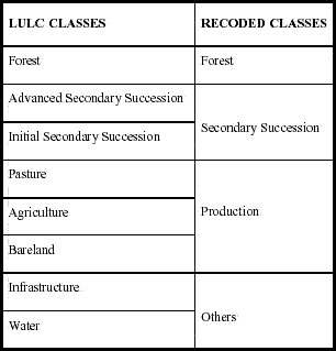
A multi-temporal approach was used to characterize landscape change in Machadinho and Anari in 1988, 1994, and 1998. LULC classifications were similarly recoded for both settlements to facilitate interpretation of landscape pattern and change (Table 25). The recoded classes were based on the main processes occurring in the study area and affecting landscape transformation, that is forest fragmentation through deforestation, vegetation recovery through succession, and land occupation through pasture and agriculture conversion.
Table 25 - Recoding system of LULC classes for calculation of landscape metrics in Machadinho d’Oeste and Vale do Anari.
The delimitation of landscape boundaries for calculation of metrics is central, as discussed later in section 5.5.2. In Chapter 4, the largest settlement area with available satellite data was used for the calculation of LULC percentages. In this chapter, the settlement boundaries are still assigned as landscape limits. However, for Anari the boundary of the smaller subset (1994) was used to clip the classifications for other dates. The procedure left 11% of the Anari settlement out of the analysis, but allowed consistency during calculation and comparison of metrics. For Machadinho, metrics were calculated for the entire settlement, including and excluding the communal reserves. For this latter case, the reserves were considered as background with no class value.
Metrics were computed at three levels of analysis, that is landscape, class, and patch (McGarigal and Marks 1995). Each settlement was assigned as one landscape. Thus, the study differentiates the landscape of Anari with its orthogonal design of roads and parcels, and the landscape of Machadinho following topographic features. Class is the patch type (i.e., forest, succession, production land, or others). Patch was already defined in the section above and operationally corresponds to each polygon of the vector coverages. Areas smaller than 900 m2 were not computed to keep consistency with the pixel size of satellite images used for LULC classifications (30 x 30 m). By the same token, the buffer area for core metrics calculations was 90 m wide. This width was chosen based on various studies about edge effects on tropical forest remnants in the Amazon (Laurance and Bierregaard 1997).
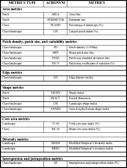
Several metrics were computed at the landscape, class, and patch levels of analysis. Table 26 lists these metrics and their respective acronyms. At the patch level, additional descriptive statistics were computed for the population of patches. Tables and graphic outputs allowed comparisons between the two landscape patterns and changing processes within the ten-year period (1988-1998). Appendix 2 describes the metrics used for each level of analysis. Formulas and descriptions were compiled from McGarigal and Marks (1995).
Table 26 - List of computed metrics for patches, classes, and landscapes in Machadinho d’Oeste and Vale do Anari.