![]()
CHAPTER 2 - ENVIRONMENTAL AND CULTURAL SETTING: THE OPPORTUNITY FOR A COMPARATIVE STUDY
2.2. The fate of Rondônia: rural development vs. landscape transformation
Cycles and interests have affected the history of Rondônia. This western portion of the Amazon was originally populated by Tupi-speaking Amerindian societies (Coimbra 1989). By the 1700s, the Portuguese engaged in several expeditions to the region, when occupation was concentrated along the Madeira, Guaporé, and Mamoré Rivers. During the 18th century, Rondônia received its first migration waves, due to gold mines found along the Guaporé River. By the end of the century, mines were abandoned and the local economy faced a period of stagnation until the rubber boom began in the late 1800s. Stimulated by the high prices in the international market, northeastern populations migrated to Rondônia and penetrated deeper into the forest to establish an extractivist economy based on rubber tapping (Rondônia 1981).
By the beginning of the 20th century, the Madeira-Mamoré railway was inaugurated. It connected the town of Guajará-Mirim, located by the Mamoré River, to Santo Antônio (today Porto Velho, the capital of Rondônia) on the Madeira River. By that time, the Brazilian government had launched initiatives to integrate the area with the rest of the country. Telegraphic lines were built, connecting Cuiabá, the capital of Mato Grosso, to Santo Antônio (Porto Velho) and the trails opened for this purpose allowed the establishment of villages. Rondon, for whom the State was later named, led the operation. In 1943, the area was designated 'Federal Territory,' and the highway Cuiabá-Porto Velho (BR-364) was opened. During that same time, rubber extraction had regained importance due to the mobilization for World War II. After the war, the activity declined and was replaced by to diamond extraction during the 1950s and cassiterite mining during the 1960s. By the end of this period, access to different portions of the territory and the demand for development required massive investments and brought about other important changes.
The recent history of Rondônia is embedded in this complex scenario. Following the national strategy of regional occupation and development, colonization projects initiated by the Brazilian government in the 1970s played a major role in LULC change throughout the State (Moran 1984, Fearnside 1989, Schmink and Wood 1992, Matricardi 1996). These projects were implemented to accommodate landless farmers coming from southern Brazil. Two large development projects are particularly relevant, both funded by the World Bank (Pedlowski 1998). The Northwestern Brazil Integration Development Program (POLONOROESTE, 1981-1985) was responsible for paving the BR-364, the main road crossing the State, which improved access in the southeast-northwest direction (World Bank 1987). The Rondônia Natural Resource Management Project (PLANAFLORO, 1992-1999) funded, among other things, the elaboration of a land zoning for the State (World Bank 1992).
In Rondônia (Figure 2), colonization projects were often designed based on an orthogonal road network, commonly called 'fishbone.' The existence of BR-364 as the backbone of this network drove rural occupation and LULC change into the State. These projects were generally implemented with no consideration for environmental constraints within the landscape or access at the local scale. The combination of a better road infrastructure and huge migration waves from the south with the lack of land-use planning within the settlements was thought to have produced the highest deforestation rates in the Brazilian Amazon during the last twenty years (Alves 1999, Dale and Pearson 1997).
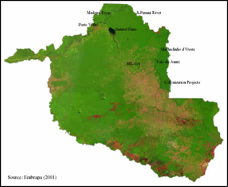
Figure 2 - The State of Rondônia seen through a mosaic of Landsat TM images from year 2000 (Bands 3, 4, and 5).
Together with land occupation and landscape transformation, new development trajectories also occurred. Logging has always been associated with road building and land clearing. Cattle ranching still occupies the largest portion of the deforested area (Alves et al. 1999), but, despite earlier predictions, less than 25% of the State has been deforested (Rondônia 1998a). Although most articles written about the State emphasize just the conversion of forest to pasture (60% of the deforested area), Rondônia is the 4th State in terms of national coffee production (Matricardi 1996). Batista (1999) makes an up-to-date socioeconomic analysis based on census data. Rates of population growth have declined drastically during the last decade, due to a decrease in migration and in fertility. Rondônia's gross State product is the 3rd in the north region, after Pará and Amazonas. Agriculture and cattle ranching account for 15%, industry for 15.2%, and services for 69.3%. The largest portion (85%) of all farms are family-managed and have less than 100 ha each. Of the total population, 70% live in urban areas.
Distinct positive forces are present today besides the always-criticized government actions and private initiatives facilitating land speculation. Non-governmental organizations have had a relatively active voice during the land zoning process (Pedlowski 1998). Native communities such as the rubber tappers and indigenous people are having their reserves delimited (Olmos et al. 1999). Conflicts still happen everywhere as reserves are invaded by loggers and road builders, properties are taken over by speculators, county boundaries are still being created, the State government claims for development, and so on (Fearnside and Ferreira 1985). But emergent grassroots organizations are becoming more active in the development process. Also, selected studies about colonization in Rondônia have led to international pressure, national policies, and local initiatives for the preservation of large patches of forest throughout the State (Rondônia 1999a).
Recently, the government of Rondônia decreed the 2nd Approximation of the socioeconomic-ecological zoning (Rondônia 2000). Still obscured by legal obstacles to be effective, the land zoning determines areas with distinct status in Rondônia. The settlements studied in this dissertation - Machadinho and Anari - are assigned to 'areas of agricultural, agroforestry, and forestry' use (Figure 3). The settlements are located at the northeastern portion of the State, adjancent to the borders with Amazonas and Mato Grosso (Figure 4). Studies of farming systems and socioeconomic characteristics at Machadinho have suggested it is a singular model of colonization design (Miranda et al. 1997). Throughout this dissertation, LULC trajectories in each settlement are related to institutional and biophysical aspects underlying landscape transformation.
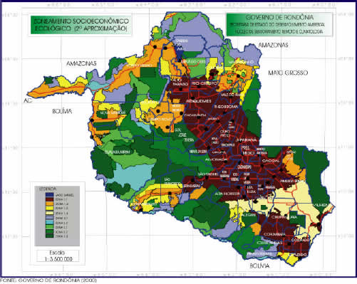
Figure 3 - Ecological-Economic Land Zoning of the State of Rondônia, 2nd Approximation (Rondônia 2000).
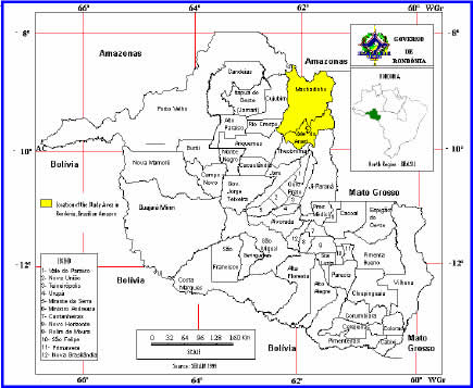
Figure 4 - Location of Machadinho d'Oeste and Vale do Anari in the State of Rondônia (adapted from Rondônia 1999b).