![]()
CHAPTER 2 - ENVIRONMENTAL AND CULTURAL SETTING: THE OPPORTUNITY FOR A COMPARATIVE STUDY
2.3. Why Machadinho and Anari?
The settlements of Machadinho and Anari were founded in the shadow of the emancipation of the State of Rondônia in 1981 when a dramatic population growth was taking place due to migratory waves. The colonization of the southern part of the State attracted a huge crowd from other Brazilian States, creating a demand for new settlement projects to accommodate the accelerating population increase.
Machadinho and Anari are adjacent to each other, and share similar features. They are located approximately 400 km from Porto Velho, the capital of the State, and present comparable biophysical characteristics at the scale of study, as described in the following sections of this chapter. In regard to their establishment, Machadinho and Anari were created by INCRA during the same period (early 1980s) and represented pioneer settlement projects in northeastern Rondônia.
Besides biophysical characteristics, an important commonality between the two settlements is related to the characteristics of initial settlers who shared similar personal traits and assets. The majority of colonists in Rondônia came from the southeast and south regions of Brazil, mainly from the States of Minas Gerais and Paraná (Millikan 1992). In the case of Machadinho and Anari, they were selected from the excessive group of applicants to earlier settlement projects, based on two sets of criteria: eliminatory criteria, including personal attributes of the candidate (i.e., age, conduct, and employment condition) and assets (i.e., income, other properties, and former applications); and classificatory criteria, including household age, family labor force, and farming skills.
The parcels handed to the settlers were about 50 ha each, half the size of other projects in the Amazon during that period. The reduction in parcel size was an attempt to accommodate the dramatic population growth in Rondônia (average of 16% per year between 1970 and 1980) (Rondônia 1996d). In sum, both settlements resulted from political pressure to accommodate landless migrants and settled households with similar socioeconomic characteristics who were granted land titles of similar parcel sizes.
Notwithstanding the similarities in some attributes, Machadinho and Anari had major differences in their architectural and institutional design. They were conceived under very distinct processes as far as farmers' incentives toward land-use decisions were concerned. They strongly differed in the implementation phase in regard to the landscape design and how infrastructure was provided and maintained during the consolidation phase. Anyone driving through the villages can easily observe the differences between the paved major streets in Machadinho with several stores and hotels and the gravel roads in the rural area, compared to the chaotic district of Anari, poorly served by services and infrastructure (Photos 1 and 2). The description underlying the characteristics of each settlement is presented below.
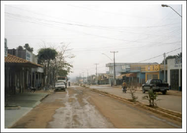
Photo 1 - Partial view of Machadinho d'Oeste (urban area).
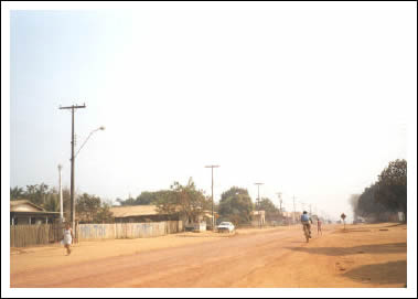
Photo 2 - Partial view of Vale do Anari (urban area).