![]()
CHAPTER 7 - CONCLUDING REMARKS
‘Eu vô num vim’
7.1. This dissertation in the context of landscape ecology
The current effort to develop a more integrative scientific vision addressing the complex interactions between people and the environment has been carried out by a combination of environmental and social sciences (Wilson 1998, Berkes and Folke 2000, Haberl et al. 2001). Scientists are building a new approach capable of addressing a variety of questions that examines multiple temporal and spatial scales (Dyson 1998, Gibson et al. 2000). Human ecology is among the antecedents of this initiative (Richerson 1977, Moran and Herrera 1984, Kormondy and Brown 1998). Historical ecology is a recent example of such a multi-dimensional approach (Crumley 1994, Roberts 1996). Other fields, such as ecological economics, promise to address sustainability of ecosystems and economic systems (Funtowicz and Ravetz 1991, Costanza et al. 1993). Completing this scenario, landscape ecology emerges as the science of 'human-altered land mosaics' (Naveh and Lieberman 1994, Forman 1997).
Landscape ecology has developed scientific bases for land and landscape management, conservation, development, and reclamation, overstepping the classical bioecological sciences and including the realm of human-centered fields of knowledge (Wiens and Moss 1999). Since its early years, landscape ecology has been cited as an 'emerging branch of human ecosystem science' (Bertrand 1978, Naveh 1982). However, as every emerging science, while the theoretical foundations have been built, there is still a lack of methodological procedures and standardization in research (M. Turner et al. 1995, Dale 2001). This makes the study of the human dimensions of landscape change a challenge (Baerwald 1991). Only recently has this 'linkage' been addressed in a systematic fashion, mainly through studies about the relationship between LULC and social metabolism (Nassauer 1999, Haberl et al. 2001).
Recent scientific priorities for research include the study of processes across time, space, and culture (Turner et al. 1990, Stern et al. 1992, Kates 1994, Arrow et al. 1995, Vitousek et al. 1997). LULC issues are at the core of this perspective, due to their intricate dynamics and its consequences in landscape structure and function (B. Turner et al. 1995, Lambin 1997, Turner 1997). In the Brazilian Amazon, this is particularly relevant because landscape transformation and forest fragmentation are occurring throughout the region (Skole and Tucker 1993, Skole et al. 1994, Laurance et al. 1997, Alves 1999). In this sense, the comparative study carried out by this dissertation offered a singular opportunity for the discussion of the human dimensions of landscape pattern and process. The rationale behind this initiative is that landscape ecology and social sciences can 'meet in the middle,' providing a meso-level integration between local and regional processes (McConnell and Moran 2001). Landscape characterizations allow a not-too-broad and not-too-fine perspective regarding transitions within Amazonian colonization settlements. As knowledge about these processes increases through studies at several scales and approaches, there is growing agreement on the need to investigate culture and context, before testing general hypotheses about human-induced ecological outcomes (Lambim 1997, Kaimowitz and Angelsen 1998).
This dissertation focuses on processes of LULC dynamics and landscape change within two distinct settlement designs in Rondônia, Brazilian Amazon. One settlement, Anari, reflects the lack of ecological and social accountability in its design, so land-use processes are related solely to aspects of how settlers can individually overcome land access and product flow constraints. The other settlement, Machadinho, represents an attempt to account - if only, partially - for ecological and social features within the system, so land use is related to how access to services and resources are filtered by different actors. The combination of privately based decisions for the properties with community-based decisions for the reserves clearly indicates that this architectural and institutional design can produce positive social and environmental outcomes in Amazonian settlements. The section below discusses the hypotheses defined in Chapter 1 based on the distinctions and similarities among the settlements (Table 42), and the main findings described throughout the dissertation (Table 43).
Table 42 - Distinctions and similarities between Machadinho d’Oeste and Vale do Anari.
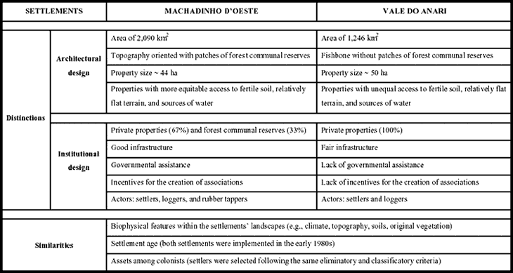
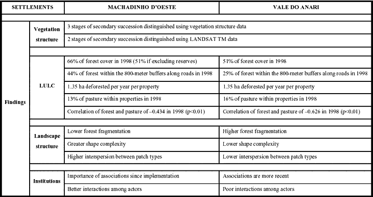
Table 43 - Selected findings of this dissertation.
7.2. Hypotheses revisited
Hypothesis 1
The fishbone settlement design of Anari leads to faster deforestation than Machadinho's architecture based on topographic features and including communal forest reserves.
As stated, Hypothesis 1 should be accepted. In fact, Machadinho had 15% more forest cover than Anari after 15 years of colonization. However, an accurate evaluation of this hypothesis depends on two main points. First, it is necessary to evaluate whether or not the fishbone settlement design in itself leads to faster deforestation than an architecture based on topographic features. Second, it is important to understand the role of the communal reserves in maintaining higher levels of forest cover in Machadinho. The first assertion is not necessarily true per se. The results indicate that it is not the fishbone design itself that is leading to faster deforestation, but the absence of communal forest reserves in Anari. Moreover, the results presented in Chapter 4 and summarized in Table 43 emphasize that the percentage of forest cover is similar between the settlements if the Machadinho reserves are excluded from the analysis. Analyses at the property level confirmed that the area deforested per property per year is the same in both settlements if averaged for the period since their implementation. However, the rate of deforestation in Anari was lower before 1988 and higher between 1994 and 1998, indicating different cycles of clearing within each settlement. As important as the amount of deforestation is the findings that pasture conversion is more prominent in the fishbone settlement (correlation between forest and pasture of -0.6 in 1998, while in Machadinho the correlation was -0.4, both significant at p<0.01). The causes for this trend were discussed in Chapter 6 and include lack of assistance, lack of credit for agricultural production, and the precarious road infrastructure found in Anari.
Hypothesis 2
Landscape fragmentation is higher in the fishbone settlement of Anari.
The striking differences in the architectural design of Machadinho and Anari suggested that the LULC spatial patterns are also different. This was first indicated by the results obtained for buffers along roads and confirmed by the analysis of landscape structure. Again, the relationship between settlement architectural design and landscape fragmentation is more complex than Hypothesis 2 states. Taking the settlement as a whole (i.e., including the communal reserves in the analysis), Machadinho's landscape is less fragmented, more complex, and more interspersed than Anari after 15 years of colonization. This was indicated by selected metrics in Chapter 5. However, the temporal factor should not be neglected. Results on the mean patch size of forest, for example, showed that Anari was less fragmented at earlier stages of its implementation. As soon as colonization and deforestation processes took place, the maintenance of forest cover within the reserves produced a less fragmented landscape in Machadinho. If Machadinho had no communal reserves, Hypothesis 2 should be rejected. Selected landscape structure metrics indicated that the design based on topography would lead to more fragmentation if it did not include large patches of preserved forest. On the contrary, if taking into account the actual configuration of the entire settlements (i.e., Machadinho with its reserves), Hypothesis 2 should be accepted. In addition to fragmentation, shape complexity, and interspersion, another important finding depicted by landscape metrics must be highlighted. That is, Machadinho's forest patches have on average more core area in relation to the total area of forest within the settlement, including or excluding the communal reserves in the analyses (Table 37). In this case, the design based on topography plays an important role in maintaining or increasing forest interior habitat relative to the entire landscape area, lowering the impact of forest fragmentation on the occurrence and distribution of organisms.
Hypothesis 3
Institutional arrangements accounting for different social actors and allowing governance over natural resources to local actors in Machadinho produce positive environmental and social outcomes.
This hypothesis should be accepted for the study area. The accountability to different actors has created opportunities for interactions with positive outcomes. Whenever these interactions are not accounted for in governmental settlement plans, chances for conflict increase. In Machadinho, this problem has been attenuated due to the implementation of communal forest reserves with right-of-use for rubber tappers. The reserves bring about another key issue in rural development projects in the Amazon, that is the compatibility of their use by local population with private lots occupied by smallholders. This higher heterogeneity of actors within the community in Machadinho fostered less conflictive situations, as distinct groups were granted with distinct land ownership regimes. In addition, the better infrastructure and the incentives for the establishment of associations in Machadinho have created mechanisms toward better and clearer interactions among actors. For instance, the enforcement of environmental laws regarding logging operations has been greatly ameliorated by the action of rubber tappers, who patrol the reserves' boundaries and denounce any invasion.
In sum, the architectural and institutional design of Machadinho has created a set of structural features that define different options of land use for the existing actors in the rural area (i.e., settlers, rubber tappers, and loggers). On the other hand, the lack of a design accounting for ecological and social heterogeneity in Anari led to higher deforestation at the settlement level, more isolated settlers, and marginalized rubber tappers.
7.3. Significance and implications of this study
Although it is appealing to compare LULC dynamics and landscape change through space and time at regional or cross-national levels, caution should be taken when suggesting scenarios. The easiest way to carry out these broad generalizations is to assume that similar processes produce similar outcomes everywhere. However, when dealing with the complex relationships between people and the environment, different environmental outcomes may result from similar socioeconomic dynamics, and distinct socioeconomic dynamics may produce similar environmental outcomes. This dissertation followed an alternative path. It addresses the trajectories of distinct settlements in Rondônia in a comparative fashion as a basis for other studies willing to contribute to the Amazonian debate regarding colonization processes within the Amazon. As far as multi-disciplinary research is concerned, the methods used were appropriate and sufficient to answer the questions and test the hypotheses listed in Chapter 1.
The benefit of this project to ongoing research at EMBRAPA and Indiana University was clear. Both organizations have carried out research related to the topics discussed in this dissertation, facilitating cooperation. The rationale behind these initiatives follows the priorities of a new research agenda on coupling of environmental and social sciences, and based on multi-level and multi-disciplinary tasks. Thus, studying biophysical and socioeconomic processes that lead to landscape variability and change in the Amazon provides important information to calibrate regional- and global-scale simulation models. Besides the elaboration of a methodological strategy based on multi-disciplinary integration for the study of colonization trajectories in the Amazon, the results of this dissertation contribute with further work using new sensors and processing techniques to improve the classification of different types of forests, stages of secondary succession, pasture, crops, and infrastructure. Achieving more accurate information on these distinct LULC categories represents a crucial step to inform ongoing research linked to enterprises such as refining global carbon modeling and LULC spatial-temporal analyses. Moreover, the use of selected landscape metrics proved to be useful when looking for indicators of landscape structure and change in the region. Last but not least, the study of the human dimensions of environmental change provided a critical assessment of driving forces leading to landscape transformation in the study area.
Four major implications of this dissertation can be identified. The first implication relates to studies on landscape characterization and modeling. The integration of vegetation structure and spectral data to inform LULC classifications and landscape structure characterizations is a robust approach applicable to other Amazonian study areas (Batistella and Brondizio 2001). In addition, comparing different designs of settlements adds to the literature available for areas of fishbone colonization. Modeling efforts such as the Dynamic Ecological Land Tenure Analysis (DELTA) (Dale et al. 1993, Modeling 1994) and agent-based simulations (Evans et al. 2001, Lim et al. in press) could be extended to simulate settlement patterns, LULC dynamics, and carbon release in distinct landscape structures through time, providing a broader approach to the heterogeneity of situations present in the Brazilian Amazon. The behavior of landscape metrics for settlement characterization and monitoring in areas of tropical rain forest can also be evaluated from a multi-temporal analysis and comparative approach such as used in this dissertation. From these evaluations, numerous applications can be derived, particularly those focusing on conservation and management of resources in colonization areas.
A second implication of this dissertation refers to the primary spatial entity within the complex mosaic encompassed by colonization areas in the Amazon and particularly in Rondônia: the rural property. Work based on household research indicates that the outcomes in terms of landscape structure are greatly affected by land-use decisions taken by landowners (Netting 1993; Pichón 1992, 1993; Bilsborrow and Hogan 1996). Attempting a generalization about the process, the World Bank (1992) tried to define a general trajectory followed by colonists in the frontier. The so-called 'peasant pioneer cycle' described how farmers had little choice when coping with environmental constraints and subsistence needs, which was consistently translated into deforestation, pasture conversion, land degradation, or secondary succession. Pichón (1997) offered a broader concept about farm-level characterizations, calling attention to 'household's demographic and socioeconomic circumstances, as well as the local and national policy and institutional context' that define the range of land-use options in the Amazonian frontier. The contribution of this dissertation to this debate comes from the possibility of tracking LULC dynamics at the property level through the integration of spatial data. The use of multi-temporal remote sensing analyses and georeferenced property grids provides accurate information about clearing cycles, land-use patterns, vegetation regrowth, and other phenomena related to farm management. When integrated with in-depth household data through relational databases, these sets of data allow powerful descriptions and predictions for a better understanding of colonization trajectories in the Amazon.
From the landscape to the farm, the dynamic character of land occupation in the region requires a multi-level framework that address both the environmental and the community attributes to understand the structure of incentives facing actors in a situation, what choices are most likely to be made, and how these choices tend to produce particular patterns or outcomes. This framework has been developed and applied in a number of studies (Ostrom et al. 1994, Ostrom 1997, Moran et al. 1998). As a comparative case study in the Amazon, this dissertation can inform the creation of robust institutions in the frontier that are resistant enough to cope with the dynamic processes of colonization but resilient enough to adapt to local and regional circumstances and context.
Finally, the policy implications of this work in Rondônia are controversial. Based on the findings of Chapters 4, 5, and 6, one could argue that the architectural design of rural settlements in the Amazon does not affect the pace of deforestation at the property level, so it is not relevant. Others would rely on other ecological indicators to defend settlement designs based on topographic features. Others would highlight the importance of communal reserves with right-of-use to local actors and the structure of incentives in producing better environmental and social outcomes, and conclude that the colonization model of Machadinho should be replicated throughout the Amazon. This debate is crucial for further initiatives regarding settlement implementation. The important point here is to realize that there is no magic formula applicable to all ecological and socioeconomic contexts within the region. Development and conservation strategies can be informed by the results of this comparative work in Rondônia, but regional dynamics and local context should be taken into account to avoid political failures. The path for a reasonable conceptual approach explaining the heterogeneous processes of colonization in the Amazon is far from achieved. Future studies that extend the reach of this dissertation are suggested in the next section.
7.4. Opportunities for further studies
It is almost a truism that research answers a couple of questions and raises dozens of new questions. The findings presented in Chapters 3, 4, 5, and 6 are answers to the questions listed in Chapter 1. On the other hand, following the multi-disciplinary approach used in this dissertation, further studies will be necessary to uncover other socioecological processes affecting the trajectories of landscape transformation. These studies should include, for example, the integration of household data with multi-temporal LULC assessments to achieve a finer understanding of settlers' decisions regarding land use. This approach could focus on specific processes, such as agricultural intensification within properties or land aggregation by cattle ranchers. By the same token, detailed studies about the performance of rubber tappers and their decisions regarding the management of reserves should be carried out. A number of specific issues should be addressed in the near future. In particular, attention should be given to the role of associations in facilitating access to resources and new technologies (e.g., mechanization and irrigation for settlers and commercial logging for rubber tappers). Some initiatives have already started in Machadinho, where data from households and communal reserves are available (Miranda et al. 1997, Sydenstricker-Neto 2000). For Anari, the enterprise is more complex, as no data are available at the same level of detail.
Another approach would be to extend the comparative analysis between Machadinho and Anari all the way to their municipal boundaries. New settlements have been implemented within these municipalities, creating a complex mosaic of properties in different stages of development. Integration of household data for the study of settlements and census data for the study of municipalities encompassing the settlements could provide a better understanding about the multi-tiered processes occurring in areas of relatively recent colonization. Going beyond the two adjacent areas (i.e., Machadinho and Anari), comparisons with other settlements within the Amazon should also be carried out. Two promising comparisons are foreseen: the fishbone design along the Transamazon Highway (Pará) and the radial scheme of Humaitá (Acre). Upon completion of these comparative studies, modeling techniques could enhance the description and prediction of colonization trajectories in the Amazon. A useful approach could be to simulate the creation of reserves within the fishbone design and investigate their effect regarding landscape structure within the settlements.
A third study should focus on the interactions among actors within the study area. For example, loggers interact with both settlers and rubber tappers, exploiting their lands in an opportunistic fashion or through management plans for logging operations, as recently enforced by the government. The interaction between rubber tappers and settlers in Machadinho is also important. It is common to hear settlers concerned about the amount of land decreed as reserves. They say they have been trapped when INCRA assured them they could use 100% of their properties because the communal reserves would play the role of forest conservation. Recently, national and regional discussions about forest management and a new Forestry Code have required the enforcement of environmental laws despite previous agreements. Understanding how the different actors organize themselves and interact with others within the action arena may provide insights about future scenarios.
Recent trends should be monitored and understood in order to answer the following questions related to both the private properties and the communal reserves.
These questions should be addressed in a multi-disciplinary fashion, with social sciences and environmental sciences helping to identify driving forces affecting LULC dynamics and landscape change. In this sense, various initiatives are appropriate and have already being tested. Some promising procedures include:
I plan to join research teams in Brazil to search for answers to these new questions. In this sense, I intend to participate in national and international efforts to better understand LULC dynamics and landscape change in high priority areas such as the Amazon. This personal goal is embedded in a scenario where the 'frontier' concept tends to be surpassed as new development trends take place in this region of myths and challenges. Hopefully, this dissertation and other initiatives will build frameworks that address the wide array of colonization trajectories within the region and contribute to better social and environmental outcomes in a land still searching for its destiny.